April 17, 2004
Statistics:
| Initial Target: | Mason City, IA |
| Departure: | Urbana, IL 9:15 am CDT |
| Arrival: | Iowa City, IA 1:00 am CDT |
| Intercepts: | East of Twin Lakes, MN 9:15 pm CDT |
| Tornadoes: | 0 |
| Hail: | Non-Severe: < 1/10 inch |
| Wind: | Non-Severe: not measured |
| Features: | Nocturnal lightning show: Anvil Crawlers |
| Miles: | 801.5 |
Summary:
| First interstate chase. Arrived at Iowa City at 1:30 to meet cousin and get data. Headed north targeting Mason City and waited for initiation. Cap held and storms fired after dark. Intercepted a severe warned storm just north of the MN border at about 9:15. Frequent lighting and possibly some small hail as I crossed back into IA. Arrived back at Iowa City at 1:30. Hoped to make this a two day chase Second day target area too far, headed home on 18th. |
Crew and Equipment:
| Solo chase. Equipment consisted of a NOAA weather radio, cell phone, Vortex Anemometer, TH-F6 HT Tribander radio. Photography by Skip Talbot. |
Details:
|
I had been watching the numerical weather models a week before this storm system hit. Unseasonably high temperatures (80's) were to reach into the Midwest via a warm front. Coupled with a low pressure center and upper air support, severe weather was forecasted Saturday and Sunday along this boundary in Iowa. I was focused on chasing on Sunday, since the wind sheer was much better including a dryline in the center of IA on an earlier GFS run. With a slight risk on both days I decided to chase both days, stopping at my cousin Kelly's dorm at the University of Iowa to spend the night. |
|
| I left Urbana at 9:15 headed towards Iowa City, to meet Kelly and use her computer get an update on the weather. The "shibster" crossed the Mississippi at noon. |
|
|
This was my first out of state chase. I was looking forward to chasing in Iowa because of its flat treeless landscape, and was hoping the sky would be a little less hazy then what I'm used to in Illinois, making for better storm visibility. |
|
I met Kelly at her dorm at about 1:30. Her dorm's building has the most confusing layout I have ever seen, but at least I'd have somewhere to spend the night. SPC's day 1 tornado forecast is shown at right. The cap was the limiting factor, but a few supercells were possible before nightfall where they were then expected to merge into an MCS. I targeted Mason City (north central IA) so I'd be a little upstream when the storms fired. |
|
| Arriving in Mason City at about 5, I waited for some sign of convection. I called Jenny to get some data. SPC had put a mesoscale discussion concerning a possible severe thunderstorm watch for my general area. When I got off the phone I noticed some convection to the west. I headed west out of the city snapping a shot of this high based mediocre convection. |
|
| I called Stan Olson, who was positioned further southwest near Fort Dodge. Somehow concluding better convection was behind what I was seeing, I headed a little further west and waited again. Out of cell phone and weather radio range I did not know that storms were rapidly building just to my north, obscured by hazy cloud cover. I snapped this shot of the shibster at a lonely railroad crossing just before dusk, and then headed back to Mason City to get cell phone coverage. |
(click to enlarge) |
| Unbeknownst to me, SPC finally put up the severe thunderstorm watch. Jenny informed that nothing was on the radar yet and as the sun slipped below the horizon I started to seriously believe that I had busted without a storm in sight and 500 miles on the shibster. |
|
| However, just as this sunk in I turned to the north and saw a flash of lightning. The chase was on! Stan called me back and informed me that the cell had a severe thunderstorm warning on it. I jumped on 35 and raced north towards Minnesota to catch it. Here's the radar at about this time, 8:30. |
|
| I finally got my weather radio in order. Warnings were going up left and right, and in the dark I could not tell where exactly storms were centered. I headed towards the center of the lightning activity. Excitement built as crackling bolts erupted every few seconds. I picked up two chasers on simplex with the ham radio. They were describing the same site I could see out the windshield: a low hanging white cloud, and were debating if it had an inflow or outflow origin. I tried to call them but must have been out of range and lost their signal few minutes later. A warning put Twin Lakes MN in the path of this storm and seeing the exit for it I pulled off and waited for it to hit. The lightning show was pretty good but none of the 2.5 inch hail or 65 mph gusts that triggered the warning. | |
Here's the radar at about the time I was pulled off just north of the Minnesota border. It would have been nice to have this data while I was there. I was blindly chasing warnings in the dark at this point. The warning I was following mentioned storm movement to the northeast but the cell I had a visual on was moving southeast so I missed the core of the storm, overshooting to the north. |
|
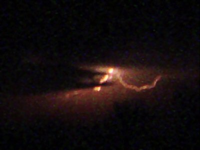
| I tried to get some pictures of the lightning with my digital cam. I tried to extend the exposure time and get better lighting by increasing the speed to ISO 400. My camera really has no good way of extending exposure time to properly shoot lightning though. Here's the best I could manage, however, it does not do the storm justice. |
|
| Recognizing that the storm activity was to my south in
Northern Iowa I got back on 35 heading south. I hit a precipitation
core with very heavy rain and could hear a few small pings, possibly small
hail. Quarter sized hail was estimated with all these storms so I
pulled off at a gas station to shelter the shibster if larger stones came
in. The larger hail did not show and I got back on 35.
|
|
| A tornado warning went up for the county Mason City is in, along with a tornado watch for the whole area. I raced south towards Mason City hoping to catch something but not run into it. The storm was off to my east by the time I got there. Lightning illuminated some ragged cloud bases but nothing that hinted at a wall cloud or funnel. |
|
| Two tornado reports came in with this storm but I did not
see any damage on my route or any large hail. As the storms moved off
into the east and developed into an MCS, I called it a chase and headed back
towards Iowa City. I believe it was almost 11 when I made it out of
Mason City and 1:30 before I made it to Iowa City. SPC's 0z day 1 for
the 18th had a 15% for tornado with a significant tornado probability for
north central Iowa. That got my spirits up so I decided to chase
again. Despite the humid heat in the dorm and the loud college student
antics, I was exhausted and crashed hard. I awoke to find a new day 1
forecast that dropped the tornado percentage to 5% and moved it to the South
Dakota border and central Minnesota. I put 800 miles on the shibster
the day before and I was not about to drive even further with class on
Monday. I called the chase off and headed home at about 12:30 and got
back to Urbana around 4:30 Sunday afternoon.
|
|
 |
|
| Conclusion: This, folks, is what storm chasing is about: driving and more driving. I spent over 12 hours behind the wheel (almost doubling my chase mileage) on Saturday with just a slight chance of seeing severe weather. Despite the lack of severity and the nocturnal storms, it could have been worse. I could have driven 800 and seen nothing. The chase did pick up at the end with an exhilarating warning chase and explosive convection firing all around. Sunday turned out to be a much more active day (as expected), with storms firing in the afternoon, PDS tornado watches in Minnesota, and a rotating line on the west Iowa border. However, the action was well out of my range and I feel no guilt for calling it a trip Sunday morning.
|
|
Lessons learned:
|
|
|
|
|