Saturday was the biggest day of a multi day run to the plains for storm chasing with Jennifer Brindley Ubl and Brad Goddard. The setup featured an extremely potent set of ingredients and a tornado outbreak appeared likely. |
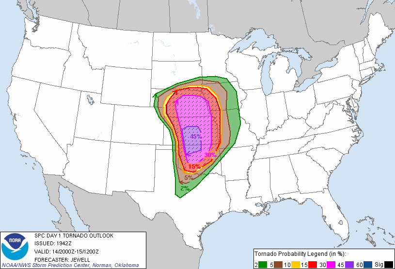 |
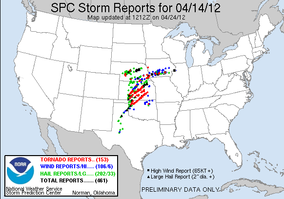
A very powerful, 70-80 knot midlevel trough and deepening surface low was ejecting across the central plains atop a sharply defined dryline extending south across the central and southern plains and a warm front across Nebraska with moderate to strong instability in the warm sector. A pronounced low level jet was forecast to ramp up at sundown further enhancing the tornado potential. Severe parameters were off the charts with the NAM and RUC models plotting Significant Tornado Parameter values well over 10 in some locations and 1km EHI over 12. Storms that initiated in this environment would very likely produce tornadoes, and possibly large, violent ones. The big uncertainty, however, was how many storms would go up. There appeared to be more than enough lift along the dryline and warm front and the cap was well eroded by mid afternoon, however, the models were having difficulty with the setup and were not firing much convection across the warm sector. Lack of convergence on the dryline and fairly weak midlevel lapse rates looked like they might hold back some updrafts from initiating and strengthening. The Storm Prediction Center was on top of the situation, however, and realized that the extreme set of parameters would more than likely overcome the few negative factors that were holding initiation back. An unprecedented High risk on the initial Day 2 outlook (the outlook a day before the event) was issued, and the morning of the event an extremely impressive tornado outlook was issued with probabilities set at 45% for tornadoes occurring within 25 miles of a point in the central plains. I had never chased an event with tornado probabilities that high.
A nagging uncertainty for Jenn, Brad, and I was where we were going to target. The warm front often features the best directional shear, with high helicity values that result in supercells that spit out dozens of tornadoes when they latch on to the boundary. Storms can be grungy, low contrast, and not as photogenic in this area as other convection and precipitation often obscures the view and the low temperature and dewpoint depression results in low storm bases. Down the dryline, it wasn't known how far south the storm coverage would extend, or even how many storms there would be. The day before, the safer play to ensure a tornado intercept seemed like it was favoring the triple point/warm front in central Nebraska. The morning of the event, the tables turned and we started to eye the dryline as our primary target. The warm sector across Nebraska appeared socked in with clouds, temperatures in the early morning were just above freezing and dewpoints thirty degrees less than what was forecast for late afternoon. Conditions rapidly change during high risk events with dramatic warm air advection likely, but it still seemed questionable that the forecast instability values would be realized on the warm front with the current surface observations and lingering cloud cover. To the south, there was a pronounced dryline bulge forecast to push out across southwest Kansas with moderate to strong instability. Lift on the top of the bulge should be more than enough to fire off a few storms, and the shear profiles were extremely favorable for tornadic supercells. We made plans to play the top of the bulge, just south of Salina, KS, taking 35 from Chickasha, OK to 135 north of Wichita and then 70 west to Salina where we'd let storms come to us.
Disaster struck our group the night before the chase. Brindley came down with what looked like the flu. She wanted us to leave her behind at the hotel and find another way home, but not wanting to leave her there sick and alone, we were able to convince her to come with us. Luckily Brad had brought an air mattress and sleeping bag. We put a seat down, cleared a space, and Brindley was able to sleep in the back as we started moving north. We made great time to Wichita and continued on to McPherson where we stopped for grub, gas, and data. Skies were overcast and the air was cool but moist. Surface winds were howling out of the south. It felt just like many other high risks I had chased before.
Visible satellite showed clearing in southwest Kansas and the airmass was rapidly destabilizing there. Lines of cumulus were forming on the dryline down there. The Storm Prediction Center issued a mesoscale discussion saying a storm initiation was imminent. A particularly dangerous situation tornado watch quickly followed. We were sitting square in the middle of the highest forecast tornado probabilities, but storms would soon fire well to our southwest and we'd be out of position if we didn't move. We scrambled to get our food and get out of McPherson. Storms fired 120 miles to our southwest. They'd need some time to mature, the best tornado parameters wouldn't materialize until early evening, and storms were expected to stay discrete until then. We still couldn't miss any of the show, however, and raced southwest for the intercept. Highway 61 out of McPherson took us directly to the storms, which were also moving toward us at a good clip, so it didn't take long to close the 120 mile gap.
Disaster struck again. While driving 70+ mph, into a 30 mph headwind, we passed a dump truck on the two lane highway. The wind buffeting was extreme, and the flow, exerting tremendous upward force, worked itself under the lip of the acrylic dome mounted on the roof of my van that I use as a video shooting platform. The quarter inch acrylic cracked with a sound like a gunshot and the dome broke free of the latch that holds it down, swinging freely in the wind by the hinge holding it down in the front. We pulled off immediately to asses the situation. The dome would have to be replaced for certain, but more concerning was what we were going to do with a now gaping 18" hole in the roof in the van. There was no way to attach the dome back to the hinge, the plastic had completely cracked off. Exposed to the elements there was no way we could encounter any sort of rain. Our chase and possibly even our drive home were compromised.
|
| Brad saved the day again. He had grabbed a roll of duct tape before we left. Brad hopped up on the roof and tore off a couple dozen lengths of tape and affixed them all around the remaining flange of the dome and to the roof of the van. Another couple dozen lengths went across the strands affixed to the roof. It was a quick and dirty fix, but it looked like it would hold strong the rest of the chase. Best of all, we could still use the dome to shoot video from, even if it didn't open. We were rolling again within a few minutes, Brindley feeling a little better as well. |
 |
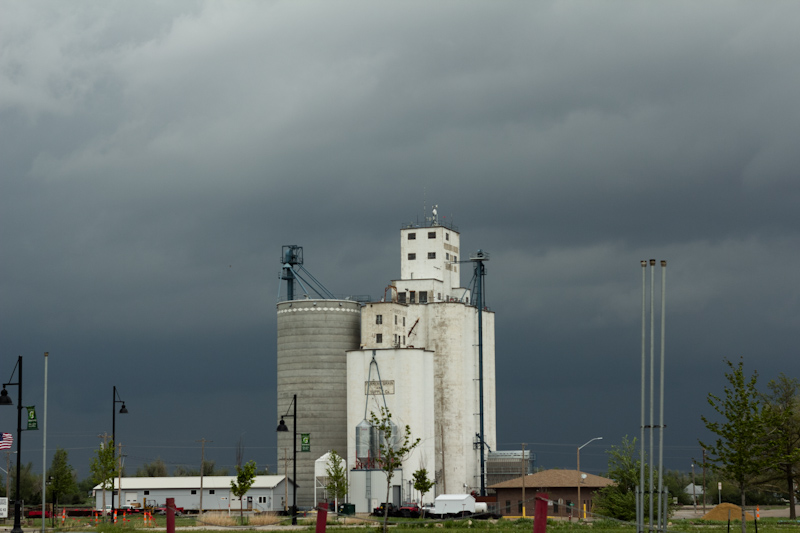
Just a few miles from intercepting, we drove through Greensburg, KS. The majority of the town had been completely destroyed by an EF5 in 2007. Nearly five years later, much of the town had not been rebuilt and only open grassy plots remained.
The Greensburg grain elevator with building storms beind it: |
 |
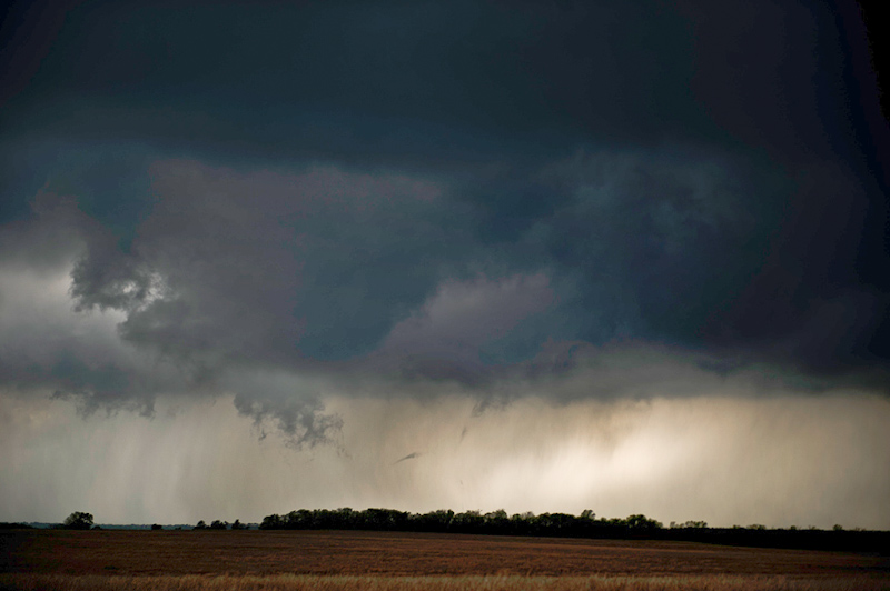
Near Mullinville, our first storm of the day came into view, a dark base off to our north. The cell had been our target for the past hour as we raced to meet it. We drove past it, however. Another cell had sprung up just behind it and quickly became dominant, displaying a classic supercell return, while the original one became elongated and started to rocket off to the north like it was elevated. Our new target trailed just behind it, a rain free base with some scud condensing underneath. We turned north for the intercept. Our storm presented a large, low wall cloud, which was probably more of a high precipitation gust front. |
 |
| The base looked low and menacing, was fairly low contrast, and didn't present a specific point of interest for tornadoes. I was hoping to see a more visible and classic supercell structure on a day with such ridiculous parameters. We continued north to get into the inflow notch and get better contrast under the base. We encountered our first chaser convergence of the day. Bill Oosterbaan and Bob Hartig said hi, and I got to meet Caleb Elliott, another fellow chaser and pilot. |
 |
The base surged forward toward us. The warm surface winds gave way to a puff of outflow, which then quickly switched over to impressively strong, cool moist inflow. The inflow was feeding into a lowering portion on the back of the base. A tornado seemed imminent. While everyone was chatting and shooting pictures, I jumped into the van to backup and get the dome camera within view of the feature. Jenn and Brad jumped in thinking I was leaving without them, and we wound up taking off anyway. |
 |
| The gust front was moving overhead and the feature away to the north and we'd have to move to keep up. We went a few miles down a gravel road to a paved north road. Our next paved road was a couple miles into the core of the storm and took us underneath the low hanging gust front/wall cloud. Driving under these features is a dangerous maneuver and I didn't want to risk driving into a tornado or huge hail, especially on a day like this one with crazy parameters and forecast probabilities. |
 |
We turned around and headed to the next gravel that went east. It started out ok at first, but the road gradually started to go downhill after a couple miles. Storms had passed through the area already and parts of the road were slick clay. We started to fishtail a bit and I had to slow us way down, falling behind the relatively quick moving storm. I turned us north and up ahead we saw big mud filled ruts and standing water on the road. I wasn't about to get us stuck out in the middle of nowhere Kansas. Brad, the better driver, and I switched seats and he backed us away from the slick mud while I routed us to pavement.
Pavement was a couple miles to the west. We had fallen well behind our storm which was moving nearly 40 mph to the northeast and was already several miles away. We'd have to speed to catch it again, and it would take us quite some time. There were developing storms to our south, however, and the air ahead of them looked clear making for clean inflow, while our storm moved into the thick cloud cover of the relatively cool warm sector. I thought for sure that the southern cells would quickly become dominant anyway, so we decided to abandon the storm on which we had fallen behind and make for newer development coming up from the southwest.
We cut south back to highway 54 and drove through Pratt, passing the same intersection in town for the fourth time on the trip. The forward flank of the storm was starting to cross the highway east of town. I didn't see any large hail reports coming in on the storm and it looked fairly small on radar, so we decided to punch the storm from behind. We hit some heavy rain, but not much hail at all. I was surprised given that this was supposed to be an extreme day. |
| We cut south through the storm a few miles east of Pratt and emerged right in front of the rain free base. A gorgeous glowing precipitation core extended off to our right. |
 |
| As we drove south, a wall cloud emerged from behind the core, brightly illuminated by clear western skies. |
 |
| The left edge of the wall cloud twisted and turned in what looked like an attempt at spinning up a large funnel cloud. |
 |
| Overhead, there was a broad rain free base. A line of scud started to feed into it as a new wall cloud formed ahead of the old one. The storm was cycling, undergoing a mesocyclone handoff, directly overhead. |
 |
The new wall cloud that was ramping up started to move off to the north. The forward edge condensed quite low to the ground and was becoming low contrast as it moved between us and the forward flanking core. We jumped in the van to keep up, while we were passed by Ben Holcomb and a few other chasers, only the second smattering of chasers we had seen on a day that was expected to have sprawling hordes.
We stair stepped to keep up with the storm, while it appeared to sputter on the radar. Meanwhile, the storm to the north that we had abandoned really started to ramp up. A string of tornado reports came in on it and we knew we were missing a show. As our storm started to look a little sloppier on the radar, the tornado warning was dropped in favor of a severe thunderstorm warning. I had been watching the cells all day, and one unusual trait they seemed to have is that the tornado cycles were offset from the radar reflectivity cycles. Just as the storms looked sloppy on radar, they'd produce tornadoes. It appeared to throw the NWS off as they'd drop the tornado warning just as reports came in, and would have to re-warn the storm. Our storm appeared to be doing the same thing now. |
A nice bowl shaped lowering developed under the base. We stopped in a spot with clear views to the north and west and watched it. |
 |
A small cone funnel soon developed. Finally, was this our first tornado? The small funnel tightened up, spinning faster and extending down from the base as a rope. I ran back to the van to report it, but I had no cell signal at the remote corner at which we stopped. |
 |
| As the funnel condensed down, I realized it was also roping out. Barely half way to the ground, this is all our storm had in it. The updraft strength or low level instability just wasn't there. |
 |
| We watched the wall cloud for a few minutes before moving to keep up with the storm. |
 |
We stair stepped with our storm all the way to Hutchinson, KS. The further we went, the more the storm seemed to fall apart, however. The base became higher and higher, mushier looking, and lower contrast as rain started to fall through what should have been a rain free base. The radar reflectivity for the cell continued to shrivel again. We got much needed gas in Hutchinson and decided to bail on our storm, heading south for a strengthening, tornado warned supercell coming up out of southern KS. I wasn't sure why our storm had failed, and the one to the north continued to go strong, but I hoped our new target wouldn't suffer a similar fate as the one we were just on. |
It was another agonizing thirty miles to traverse to our new target before we had a view of the base, as we hoped the whole way down that our storm would hold off producing until we got there. We wound up back on highway 54 for the third time that day, heading west. The base of our storm came into view near Kingman with an elongated and scuddy forward flank. The rear flank, our point of attack was not very prominent, but was still several miles to the west. We moved north toward Varner, stopping just shy of the precipitation in the forward flank, and getting right into the inflow notch, letting the storm come to us. |
 |
The storm rapidly organized, with a rain free base developing a nice kink where it met the rear flanking core. A nice pointy lowering rapidly condensed almost to the ground. It was at least a scuddy looking funnel and possibly a weak tornado. We watched it hoping it would tighten up some more but it quickly fell apart. The base above it exhibited strong rotation, as it moved directly at us. We held our position as long as we could until the feature moved overhead. We jumped back on the road heading east, and just in time too. A long string of cars, maybe one or two dozen in all, was heading our way from the south. It was the first large chaser convergence/traffic I had seen all day, but hopping on the road we were still ahead of the crowd. |
 |
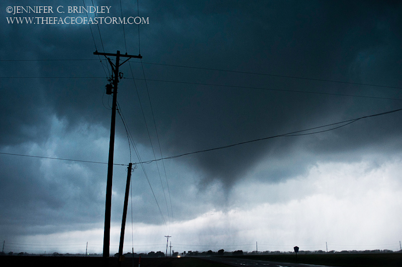
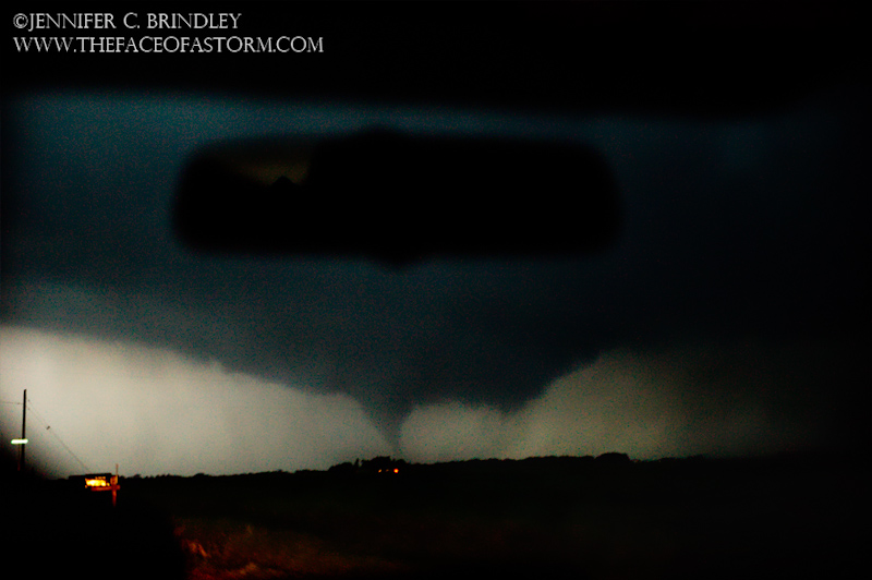
As we drove east, Brindley watched out the back window and I watched the video feed as the camcorder was pointed behind us as well. A well formed trunk shaped funnel was hanging from the updraft base. Brindley called it out just as what was probably a mix of a powerful rear flanking downdraft surge and broad circulation crossed the road behind us at a distance of a hundred yards or less. A series of four brilliant green power flashes ignited from the power lines behind us. You could see sparks showering down on the road after each flash. The funnel aloft seemed to be rotating around a broader circulation that extended to the ground, mixed in with the RFD below it. Other chasers later noted there were multiple funnels around the feature, a weak multivortex tornado. Funnel aloft and damaging circulation on the ground, we had our first tornado of the day and reported it on Spotter Network. |
 |
We cleared the tornado without issue, as it moved northeast across the road behind us and we sped ahead of it to the east. The first car in the long line behind us, however, was just turning at the intersection we had been stopped at. Following just moments behind the power flashes, they were driving essentially within the circulation. The tornado was relatively weak, and the car emerged out of the surging rain bands unscathed, but it seemed like a very precarious position to be in. |
 |
The funnel persisted, but quickly became rain wrapped in the RFD. We drove east back to the highway we came down on and headed north. The rear flanking core cleared out and a large turbulent clear slot bowl was exposed. |
 |
| Heading east again toward the Cheney Reservoir, a funnel started to dangle from the back edge of the updraft base. It was gone as soon as we pulled, however. The time of the funnel coincided with a damage survey the National Weather Service conducted. This funnel might have been part of an EF0 tornado. |
 |
For once the road grid was on our side. Unlike our chase on the first storm of the day, we had nice paved options to head north and east while staying in the clear air in front of our storm, until we hit highway 50 by Burrton. We drove into the forward flank of the storm to get to our east road, encountering only a smattering of rain, no hail. |
The wall cloud/updraft base crossed the road in front of us. We pulled off and let the northern end of the wall cross before we cautiously proceeded underneath the bowing forward portion of the wall cloud. A tornado should be off to our north if one developed, but I've learned the hard way never to linger under wall clouds so we proceeded with caution. |
 |
Stair stepping again, our storm was cycling again. A nice bowl shaped wall cloud formed and we were able to get ahead of it right into the inflow notch, the same position we were in on the first tornado we saw from the storm. We stopped at an intersection with a hanging caution light and watched for several minutes as the bowl shaped lowering approached our position. The rotation in the feature was strong. |
 |
| |
 |
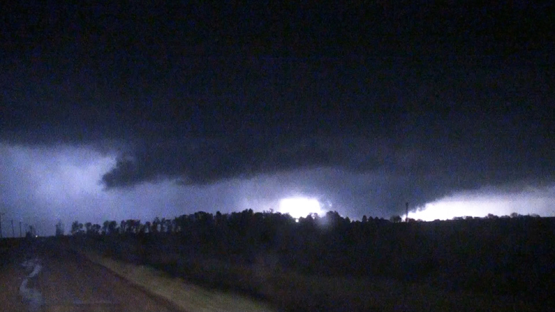
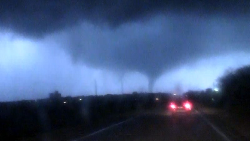
A funnel started to descend from the middle of the bowl. It was much more well formed than the first one we saw on the storm, the rotation notably stronger. Like the first storm, we were dramatically close to the center of rotation, however. The low angle of light backlit the funnel and anything underneath it quite nicely. A plume stirred up on the ground, reaching up to the funnel. We had our second tornado of the day. |
 |
The funnel continued to dip lower as it rapidly approached our position. Meanwhile, a minivan pulled up in front of us. I'm not sure if he was a local yokel, storm spotter, or other. "Got any rotation?" he asked us. Brad and I pointed over his head, "That's a tornado, that's a tornado right there!" The driver made a quick glance over his right shoulder, seemed spooked, and then took off to the south. |
 |
The tornado was moving left to right, and would pass to our north within a quarter mile. We held our ground. The wind whipped through the lines overhead making an eerie howling noise and as the tornado approached, the inflow picked up dramatically, screaming into the tornado. The flashing caution light overhead swung back and forth, the street signs rocking violently. |
 |
The tornado passed just to our north, the condensation funnel still aloft, with a swirling circulation in the field in front of us. We were safe and clear of the path, but it was exhilarating being that close. We had already caught a tornado, but Jenn exclaimed that now we had a real tornado. |
 |
The tornado was moving rapidly northeast, and we quickly lost our contrast as it moved past the backlit western sky. We headed east until we had an unobscured view to the north. The tornado fully condensed into a large cone, the last of the day's light illuminating it in blue shades. |
 |
| |
 |
We watched it for a couple minutes until we started losing our contrast again. We headed east and then north just before Hesston, sirens wailing in town. North of town we got a low contrast of the tornado as it became rain wrapped in the core of the storm. |
 |
We stair stepped with the storm. Near Goessel in the fading twilight, the wall cloud cleared out, cycle and another funnel started to descend from the base. It descended to the ground as an elephant trunk. |
 |
| |
 |
We turned north past Goessel to get closer and were greeted by a large stovepipe in the last of the remaining light. We tried to get closer, but the best we could do was keep up with the fast northeast storm movements. |
 |
We followed the storm into the darkness. Near Hillsboro, Jenn spotted something looming to the northeast under our storm, backlit by lightning. "Is that a wedge?" Lightning lit up the feature and it did indeed look like a huge wedge tornado.
We watched it for a few more flashes. The feature was dramatic, but at our distance and with the terrain we couldn't be certain that it was actually on the ground. |
 |
Turning east between Marion and Hillsboro, we got a little better look as we passed the feature from the south. It did appear that we were looking at just a large wall cloud, but it really had us going for awhile. |
 |
Turning north toward Lincolnville on 77, we fell in line with a few other chasers. We were slightly east of the storm and hoping to make up some ground it. The storm cycled with a nice bowl meso. |
 |
| Lightning illuminated a cone funnel. |
 |
Within a couple minutes of watching lightning flashes, we had our fourth and final tornado of the day: another stovepipe. |
 |
The stovepipe crossed the road a couple miles ahead of us near Lincolnville, while becoming wrapped in rain. |
 |
Most of the chasers turned east to follow the storm in Lincolnville. Lightning, had dropped off, and we were behind a rain wrapped meso with no view. We'd have to proceed cautiously and wait to make sure the meso had crossed the east road to the north if we were going to proceed. Hook slicing at night is just too dangerous. Jenn, Brad, and I were exhausted, and had our tornado fix, however. Instead of following east, we decided to call it a chase and head north to Junction City for some grub and a room for the night. We headed north expecting to cross a tornado damage path, but the stovepipe must have crossed the road in an open area or been fairly weak at the time as we didn't see any debris.
We were hoping to get steak dinner as Junction City is metropolis by Kansas standards, it wasn't even 10pm yet, and a Saturday. We found nothing open except for fast food, however, so we wound up at Sonic. We tried to reserve a hotel room over the phone, but we were put on a hold. We didn't know it at the time, but a couple of storm chasers had come into the lobby and spooked the clerk about some storms that were heading our way. The clerk never reconnected us and we had to drive to the hotel to see if we could get a room. She was still frazzled by what the other chasers said. We tried to reassure her, as the storms were more than an hour out and not guaranteed to hit at all, but it didn't help much. |
We got our rooms and started to unload our stuff, but not completely. Tornado warned supercells were indeed heading our way. We weren't about to take shelter from them either, as it would be much safer to simply evacuate to the south. We watched the cells approach on the radar and with them twenty minutes out we decided they were going to pass a little too close so we piled into the van again and dropped south a few miles, finding a hill where we could watch the storm go by to the north. Our hill didn't have much of a view though, and the storm missed Junction City to the north, so we headed back to our room and crashed. |
|
| Conclusion:
The Storm Prediction Center's high risk outlook verified, with a tornado outbreak occurring over central Kansas. The high risk initially included Nebraska, but this end of the event failed to live up to the probabilities with only a couple of tornadoes reported. The storm of the day wound up being the one we were on initially. Well after we left it, it produced a large EF4 southwest of Salina and miraculously with no fatalities. The only fatalities of the day came out of Oklahoma. With so many tornadoes and the potential for long track, violent tornadoes, it was very lucky that that most of the tornadoes had missed the larger towns and cities and there weren't more fatalities. We were disappointed that we hadn't been on the largest or most photogenic tornadoes, but we were quite happy with what was a very rewarding albeit hectic and at times frustrating chase. With a photogenic tornado, dramatic front row seats to the formation of two, and a couple more after dark thrown in for good measure, the chase made our trip.
|
|
Lessons Learned:
|
|
 |

