May 9, 2013
Statistics
Clinton, OK 9:35 AM 5/9/2013
Mason, TX 9:55 PM 5/9/2013
Sweetwater, TX, Winters, TX, Ballinger, TX, Mason, TX
Summary
Dryline supercell in central TX. Targeted Abilene for afternoon initiation of supercells with minimal tornado threat. Intercept tornado warned supercell south of Sweetwater with developing wall cloud but quickly transitioned into HP. Dropped down line of cells to sculpted "bat wing" supercell. Overtaken by core with barrage of hail over 1" and a few golfballs. Sheltered in out building before dropping down line again noting photogenic bases before stopping for the night in Mason, TX.
Crew and Equipment
Chase partners: Jennifer Brindley Ubl. Equipment: Canon 60D, Canon t2i, Canon EFS 10-22, Canon EF 50mm, Sony HDR-xr500v..
Video
Map
Details

Our second chase day on this plains trip, Brindley and I were planning on diving deep into Texas and chasing further south than we ever had before and for a string of marginal setups. It was May, however, and we wanted to chase so it didn't matter to us how far our journey would take us from home. We awoke in Clinton, OK under warm, sunny blue skies. We grabbed a quick continental breakfast at the hotel and checked the data picking out a target for the day. A dryline was forecast to setup across central TX and points south, with a bulge just south of Abilene and a decent chunk of midlevel flow bisecting it. Our target would be the top of the bulge near Abilene where afternoon storms would hopefully initiate and take advantage of the midlevel flow. Low level wind shear was paltry, however, so the tornado threat was expected to be minimal. SPC went with a less than 2% outlook for tornadoes for the first few morning outlooks before finally upgrading to 2% in the afternoon. Still, with moderate to strong instability, steep lapse rates, and some speed shear, large hail and a few supercells looked more than possible across central Texas and that was good enough for us. We loaded up the van, chatting with Tony Laubach and Tim and Paul Samaras who also happened to be staying at the same hotel. We didn’t know it at the time, but this would be the last time we would ever see Tim and Paul. They were tragically killed by the El Reno, OK EF5 just three weeks later. I’ll always remember how outgoing they were to others and how passionate they were about chasing. Tim was always happy to see other chasers and would excitedly talk about his latest endeavors. We told them we were heading into Texas for the day, and Tim wished us luck while asking if we had some heavy sheet plastic in case we lost all our windows due to large hail. They were out for shots of tornadoes, however, and didn’t have their truck to do lightning research so they weren’t going to make the long haul into Texas for an almost nil chance of a tornado. Tim was quite excited for a project he was working on later in the month though, which involved a grant to study lightning activity near windfarms. We said are farewells and started heading south into Texas.
We made good time heading into Texas. It was my first chasing in the state since 2010 and Brindley’s first time since 2007. Heading into Abilene, storms were already starting to fire to our southwest off the top of the dryline. The first few storms were north of a warm front and were probably elevated, but new activity was rapidly developing south down the dryline. We scrambled to get through town quickly so that we wouldn’t miss the show, taking I-20 through town in fairly dense traffic. West of town a line of storms started to come into view as the northwest horizon turned a dark blue. We exited heading north toward the line. A rather unimpressive shelf cloud came into view and we had no real point of attack for any sort of supercellular structure.
The tail end storm started to organize back toward Sweetwater so we moved west a ways and then got south of the interstate into the storm's inflow notch. There were enough roads to pick from, but they all run in weird angles in this part of Texas, which made navigating a little trickier than usual. We found a spot with a great view to the west and let the storm approach our position. The northern end of the horseshoe shaped base started to lower and develop a bit of a tail cloud. We had a developing wall cloud, and our first real supercellular structure of the day. We stayed for several minutes, the wall cloud not organizing much further, until it was time to move, while nearby residents stared at us curiously.
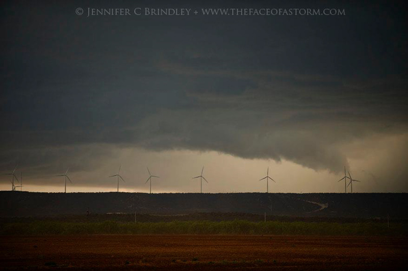
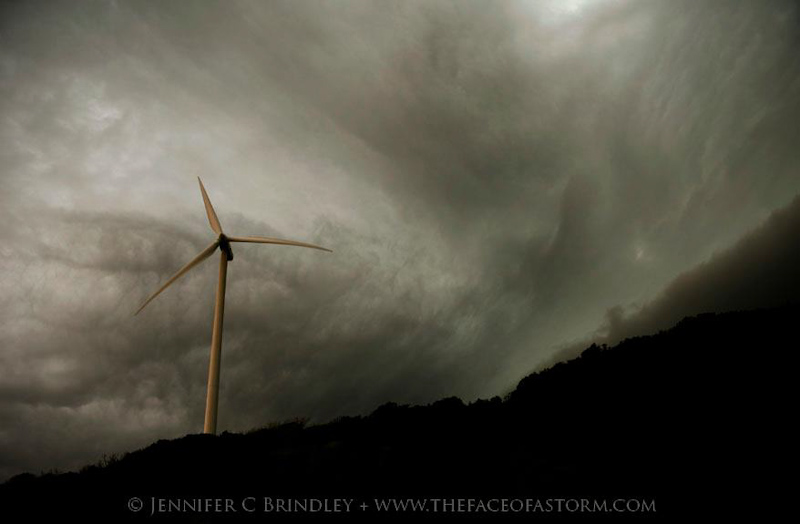
Our chase got momentarily nerve racking as we tried to navigate through some hilly terrain and winding roads. The core of our storm was getting precariously close and we didn’t want to get caught in huge hail or a surprise tornado. We wound our way through the hills amidst a windmill farm, unable to see the base of the storm as it loomed out of view while encroaching on our position.
We finally caught up to a highway that went straight west and were able to get out ahead of the storm again. The storm also went tornado warned at about this time, which got us more than excited since our chances of seeing a tornado were supposed to be quite slim on this setup. We were still in hilly terrain, however, and were struggling to find a place with a view. There was a private drive off the highway with a gate that was open that went straight up to the top of the hill. We took it, hoping the residents wouldn’t mind us stopping in for a short visit. The view at the top of the hill was perfect, looking out across the scrub filled hills while the storm presented us with high precipitation supercell structure. A meaty tail cloud was feeding into the rear flanking core which would probably obscure any view of a tornado, but we watched it hoping visibility might improve. Meanwhile, a Jeep pulled in behind us on the one lane drive and an older gentleman got out, scratching his head at the van parked in front of him. I feared he might be a proud Texan, upset at catching some trespassers. He was quite friendly, however, and eager to hear about the storm when we told him we were storm chasers. We could hear the faint sound of sirens in the distance from a nearby town, but our view underneath the storm never opened up and the structure started to look a little junkier. It was time for us to move to stay ahead of the storm so we thanked the man for letting us stop on his hill while informing him that he might get a little hail from the north part of the storm but that he was probably clear of any potential tornadoes.
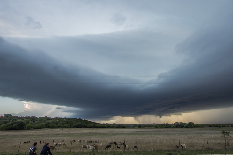
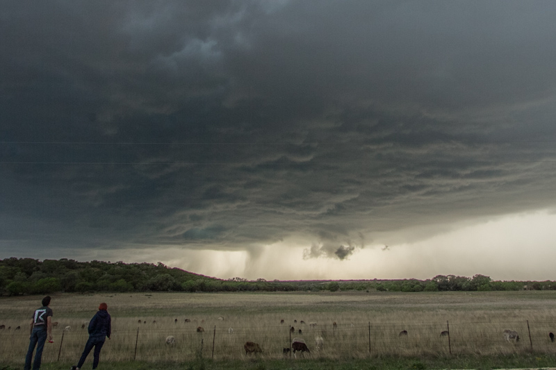
Heading east, our storm gusted out and lost its warning so we decided to leave it and start heading south down the line to newly developing storms. The first one we passed looked high based and like it was on the verge of gusting out as well. Brindley, doing some navigating through Winters, gave us the laugh of the trip when she was trying to find Santa Fe St. but misread it as “Santa Fest”. South of Winters our next storm came into view, and it was the beautiful supercell that we had been waiting for. The base was high contrast and free of precipitation except for a bright white hail core extending off to the north. The undersides of the clouds were dark with a neat texture. Ahead of the storm, feathery thin curtains of cloud flowed in with the storm’s inflow. It reminded me of bat wings or dark, flowing silk and gave the storm an eerie, evil feeling as if it were a witch riding in the wind.
The base approached with beautiful lighting and textures as if it had been sculpted by an artist. We couldn’t make out much rotation and the storm otherwise did not look very favorable for tornadogenesis, but it was so photogenic that didn't matter at all.

Shooting the storm
8 miles SSE of Winters, TX
4:40 PM
Brindley snags my picture as I work the roof mounted camera, shooting a time lapse sequence of the storm's base.
As we stood in awe of the beautiful storm, we were distracted from the glowing white hail core that was moving closer and closer to us. We realized we had lingered too long and scurried to get in the van and out of the way of the storm. I quickly realized that I had also neglected the map and our next east option was several miles to the south. We wouldn’t clear the rear flanking downdraft in time and were going to get cored on a day that was forecast to have huge hail. The white curtains of the core started to cross the road ahead of us and the first few stones started to strike the van with their telltale sounds, forewarning us that all hell was about to break loose: “dink… ping… DONK… thunk!” A little red VW bug behind us was desperately trying to go faster or get around us, looking for cover. We were traveling slowly looking for our best road option, knowing we couldn’t avoid the core at this point, so I pulled over and let him pass. He zipped around us, before darting off the road with a pickup truck and underneath a tree that would provide meager protection from the hail.
We continued on, the hail just starting to pick up in frequency. Brindley spotted a farm off to the right and the gates were open. With the rear flanking downdraft blowing the hail to the east, I hoped to pull up along one of the out buildings and get some partial shelter from it as the hail blew over the top of us. With such a potent looking supercell, I feared if we took the brunt of the hail core that we could lose all of our windows, which would cost us the rest of the chase and potentially the rest of the trip. We drove in and pulled up to a shed just as the hail started to really come down, making our visibility difficult. The large doors on the front of the shed were open and there was plenty of open space inside for the van. “Go in there!” Brindley shouted and I nosed the van inside just in time. The storm opened up seconds later with a terrific hail barrage. We stepped out of the van to watch the show behind us. The sound of thousands of large hail stones striking the corrugated metal roof of the shed above was absolutely deafening. We watched in amazement as the hail quickly blanketed the ground in white and shredded nearby vegetation. The wind from the rear flanking downdraft picked up and made the shed creak and buckle slightly and I worried that the entire building, not meant to stand up to severe weather, might come down on top of us. After a couple minutes of shooting hail video, the sound of hail on metal became so uncomfortable that we had to retreat back into the van. Most of the stones were probably an inch in size or a little larger, but there were a few golf balls scattered into the mix it looked like. We probably wouldn’t have lost all of our windows, but the shear amount of hail coming down was still amazing. As soon as the hail started to dwindle in size, I pulled us out of the shed and started heading back for the road, not wanting to stick around as unwelcomed guests on someone else’s property. Our ears were still ringing for a long time after we left the farm.
Having waited out the storm’s core, our storm had pushed off to the east. Instead of trying futilely to catch up with it again as it looked like it was also starting to gust out, we decided to keep heading south down the dryline and make for newer, more discrete cells. South of Ballinger we came up on to our next storm. It was super high based, so probably not much of a tornado threat, but it was pretty and sported a nice beaver tail. We bumped into veteran storm chaser Gene Moore as we pulled off the highway to watch the storm for a few minutes.
We didn’t have a very good view where we stopped because of the trees so we decided to keep heading south and west, the direction the storm was moving, to find another vantage point. The scrubby ranchland around us was all closed off and gated with hills and vegetation blocking our views. We drove for miles and miles looking for a place to stop before we finally found a wide open field with a view to the west off a little, unpaved road. The field was filled with goats, and they clustered around the fence to see us. They bleated loudly and their vocalizations sounded like human shouts and cries. It was both humorous and unnerving as it felt like there were people shouting all around us. The storm was still quite photogenic though, with a smoothly sloping updraft tower and a big beaver tail.
We finally had a chance to sit and really watch the storm for a long time. Brindley and I sat on the side road munching on some carrots and humus while the goats finally calmed down. Inflow tails stretched overhead and streaky rain curtains drifted around inside of the precipitation core on the horizon.
The updraft base started to move overhead, and once again the precipitation core was encroaching on our position. A local in a pickup came down the road and warned us that he heard reports of baseball sized hail falling out of the storm in the next town over. That was our cue to leave. Unfortunately, we had to go north a short distance, toward the storm’s core before we could go east and get ahead of the core, as the storm headed southwest right toward us. We made it north to pavement and then blasted east. The opening percussive notes of the “hail barrage song” started up again: “dink… ping… DONK… thunk!” We were flying down the road though, and pulled out ahead of the storm before it had a chance to truly open up.
With the sun setting and our storms starting to wind down, Brindley and I decided to call it a chase and get some dinner and a room for the night. The closest town was Mason. We were able to get a room at a quaint little motel and dinner recommendations from the desk clerk before the storm caught back up with us. Luckily the heavier part of the storm missed to the south so the van didn’t get smashed and the restaurant windows didn’t blow in while we were chomping on some fish tacos at the local Mexican joint.
Conclusion
There were no tornado reports in Texas on this event, but we got all that we had hoped to on this chase, shooting several photogenic supercells and one that was even warned for tornadoes. Getting caught in the hail core and taking refuge in the metal shed was one of my more memorable encounters with hail. I don’t typically seek out hail, as I’d prefer to avoid the damage it causes, but it was quite the (extremely loud) show watching it from the shed. Of course there was a tornado report that came out of central Illinois, but I’ve come to accept that will happen almost every time I leave my home state to chase the plains.
Lessons Learned
- Don't let hail cores sneak up on you.
- Be mindful and courteous when stopping on private property.