
June 11, 2016
Statistics
Summary
Upslope play in southeast Montana. Intercepted a couple of dying supercells before they died and storms congealed. Missed a tornado near Baker and called the chase.
Crew and Equipment
Chase partners: Chase partners: Jennifer Brindley Ubl, Anton Seimon, Tracie Seimon, John Allen, Rose Allen. Equipment: Canon 60D, Canon t2i, Canon EFS 10-22, Canon EF 50mm, Sony FDR-AX100.
Video
Details
"Browsing observations and the NAM, I think that the key today is to plant ourselves squarely in the high CAPE/high theta-e axis oriented ESE-WNW around Miles City and look for a sequence of storms to cross it, much like yesterday. Importantly, the axis is predicted to remain quasi-stationary (see attached). As storms cross towards the cooler north side of the axis, the lower temperatures and LCLs may provide the optimal tornadogenesis potential on each cell in succession. Yesterday’s setup was actually quite similar, albeit with lower CAPE and significant mountain obstacles, though the road network and cell reception were much better than I had expected. Although the low level shear could be stronger, I expect that there will be one or more significant tornadoes, possibly long-lived, in our target region today. "

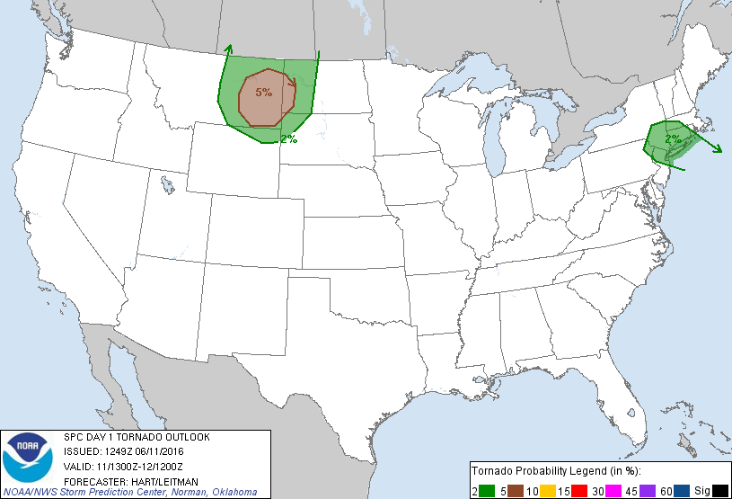
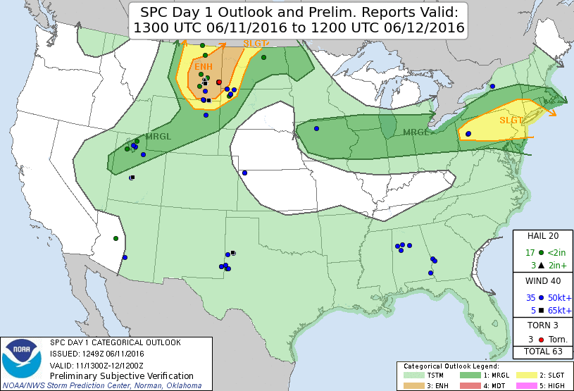
"Day 1 Synopsis: A potent surface low in north central/north east WY and southeastern MT will deepen today in response to an eastward progressing SW impulse that is hammering against the stout ridge over the midwest, central plains and into the southeast. The system has traipsed southward of previous days forecasts, with a corresponding southward shift of the severe likelihood and potential. A wind shift corridor lies between SE MT and central MT, forming somewhat of a dryline, particularly further north into the Canada, but more diffuse near the surface low. A stationary front drapes eastwards currently along the MT/WY border, while a strong axis of high 60s and low 70s dewpoints over central SD moving west toward the low. During the day the low should lift somewhat northward. Upslope flow over the Bighorn mountains will likely initiate a cluster of fast moving storms that will trail NE this afternoon, with initiation of a strong storm or storms in the effective triple point/close proximity to the low to the north of Miles City and west of Glendive where parameter space is maximized, and potential south of this area as well. High values of SCP and CAPE into the 2500-3500 will foster strong updraft development, while 50-60 knot W-SW shear vectors should foster an east or northeast moving supercell.
12Z 4km NAM puts a solution with significant updraft helicity swathes in these areas, prior to upscale growth. Initiation in NAM is quite late, with ~23Z looking likely, so we may be chasing on the edge of daylight. Unlike previous days, these storms are likely to develop in a STP bullseye, suggesting that in addition to tornadoes (5% again!) we have a chance of a significant tornado prior to the storms being absorbed into a larger scale MCS. 12/13/14Z HRRR has dispensed with the clustering nature of earlier runs, with a strong isolated supercell or supercells developing near or west of Glendive toward Circle around 22-23Z and tracking NE for a few hours.
The consensus of this forecast would appear to be expect a 2-3 hour narrow window of a strong isolated supercell over the Circle-Glendive corridor moving toward Cutherbertson/Willston by late afternoon/early evening tracking ENE. Initial target is Glendive.
Day 2: Will be primarily dedicated to positioning for Day 3 with opportunistic chase unless potential warrants a more concerted effort. Severe potential will be focused from a Corridor from MN through IA/NE and into NE Colorado and WY, with potential for supercells ahead of upscale growth in a formative environment of 2000 J/kg CAPE, associated with a lead SW impulse of the central stream trough through central CO. Shear will be favorable for supercells in the high terrain, with 30 knots or more of BWS particularly over CO, SW NE and WY and reduced further east. Initiation will be early, which may preclude target as south as central CO, but depending on depicted evolution, there should be at least some potential of supercells and storms in the region, but it will require an early start from around Dickinson, ND, particularly if potential improves.
Day 3: Lee low development in CO will foster an environment favorable to the development of moist upslope flow from central CO through to SE WY. While the details still need to clarify, the primary focus will likely be around Weld County or the Palmer divide where profiles like: http://climate.cod.edu/hanis/model/fsound/index.php?type=12|GFS|CGP|con|scp|60|40.45,-102.9|ml|severe will be common. Mid to high 50s dewpoints appear likely, as moisture is now beginning to filter north along the western ridge axis, and by 3Z, though capped, profiles in eastern CO look like: http://climate.cod.edu/hanis/model/fsound/index.php?type=12|GFS|CGP|con|scp|63|38.65,-102.11|ml|severe
Day 4: Will depend on how far the lee low now deepening kicks out into the eastern Plains - with model solutions between Eastern KS and Central IA."

"Saturday’s Montana chase was a rather trying affair. For two weeks now, we have endured a lengthy tornado-free period that defies climatological norms. So it goes with chasing. It turns out that seeing a tornado yesterday was the proverbial needle in a haystack, where multiple candidate thunderstorms produced but a single 10 minute duration tornado, and a rather unspectacular one at that from what I can tell. Nevertheless, I think that our teamwork and communications were excellent, and decision making was sound based upon the real-time data available to us. I am proud and honored to working with all of you, and have been loving every minute of the experience. Yesterday’s forecast and outcome remind me, yet again, just how much I have to learn about this strange enterprise that we enjoy so much. My expectations of one or more high-end supercells giving us a great show was nothing close to what actually transpired. A bit frustrating perhaps, but totally fascinating nonetheless."
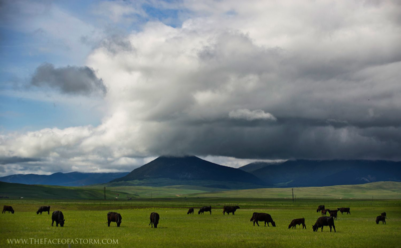
"It was a very warm day as we exited our hotel, with temperatures reaching the mid 90s and quite humid. A developing surface low was located over northeastern WY and south central MT, deepening in response to the approaching shortwave trough. This resulted in moisture advection from southeastern SD down the Plains in response to a low level jet the previous night, bringing dew points of low 60s to the high terrain of eastern MT. Given surface elevations of as much as 2500ft, this moist airmass, together with surface heating, was expected to yield around 4000j/kg SBCAPE, topped by 55kts southwesterly vertical wind shear with pronounced 0-3km backing to the southeast.
A stationary boundary anchored along the Circle-Glendive corridor, and was expected to provide a source of increasing updraft helicity as storms moved from the southwest later in the day, along with cooler temperatures that would reduce dew point temperature spreads. CAMs projected late development around the 22-23z timeframe to the southwest of Glendive and Circle, and in light of the storm motions being to the east-northeast, we positioned for an initial target of Glendive with an expectation of storms forming to our west between there and Circle.
Cells formed over the high terrain in northeastern WY and southeastern MT, tracking northward toward the favourable boundary to the north of Glendive. These high-based cells quickly became a cluster, with supercells embedded within.
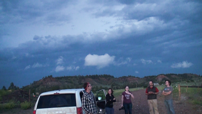
Particularly west of Terry, cells took on left moving characteristics, contrasting right moving cells on the eastern margin closer to where the winds were backed. The northeasterly inflow on the western side of the low generally lead to cells being choked by their own rain. To position, we drove west from Glendive along i94, skirting a right mover to get a look at a developing cell near Miles City. Unfortunately, in the rain cooled airmass, these cells were somewhat high based and denied access to the richer moisture and instability, along with the favourable helicity for potential tornado development.
As they moved north of i94, they took on a more MCS like structure, and we elected to let these go while heading further east toward a tornado warned storm near Baker, which had already produced a tornado. As we headed toward this cell it weakened, and the decision was made to head back west again toward a cell near Broadus. In the post MCS airmass, and with dwindling light and further upscale growth of this cell, the chase was called and we headed for ND for the night."
Conclusion
This was a bit of a grind and a bust. We were within strike range of getting a tornado on this chase, one of our best chances for the entire trip, and we missed it. I figured this would happen too. You need several chances at a tornado sometimes before you can actually nab the shot, and this one chance wasn't enough. We simply picked the wrong storm, and that stings. The Baker tornado was rated EF3 and numerous chasers caught it including the mobile radar research groups. It wasn't super photogenic though, with a condensation funnel that stayed mainly aloft and was partially rain wrapped.
Lessons Learned
- Although it's riding a huge helicity gradient, double check that north moving supercell on the far west side of the target to make sure it's not just an elevated storm stuck on the cool side of the boundary.

Webpage, graphics, photos, and videos © Skip Talbot or respective owner 2018.
skip.talbot@gmail.com Skip's Webzone