May 25, 2017

Statistics

Initial Target
Start
End
Storm Intercepts
Tornadoes
Hail
Wind
Features
Miles
Sterling, CO
Springfield, IL 3:32 PM 5/24/2017
Colby, KS 9:43 PM 5/25/2017
Idalia, CO; Goodland, KS
1
2"
0 mph
Tornado, Occlusion, RFD Gust Front, Wall Cloud
1192

Summary

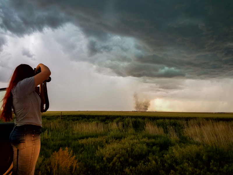
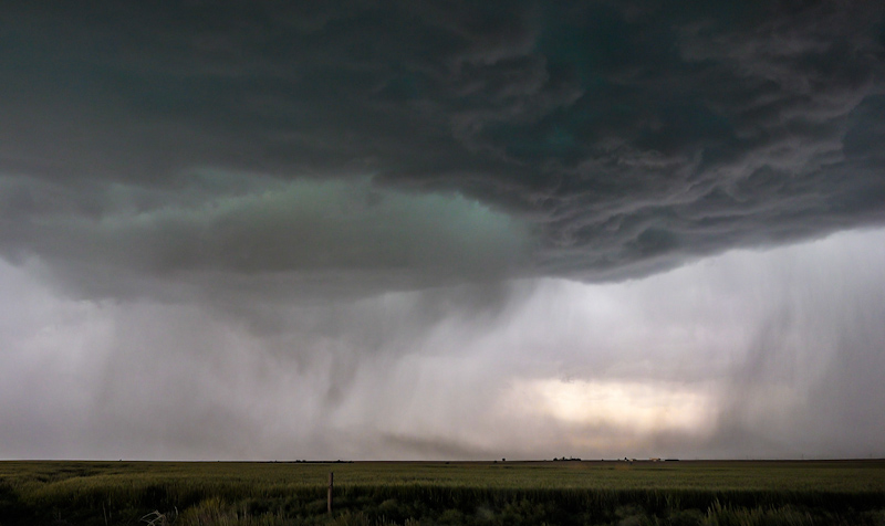
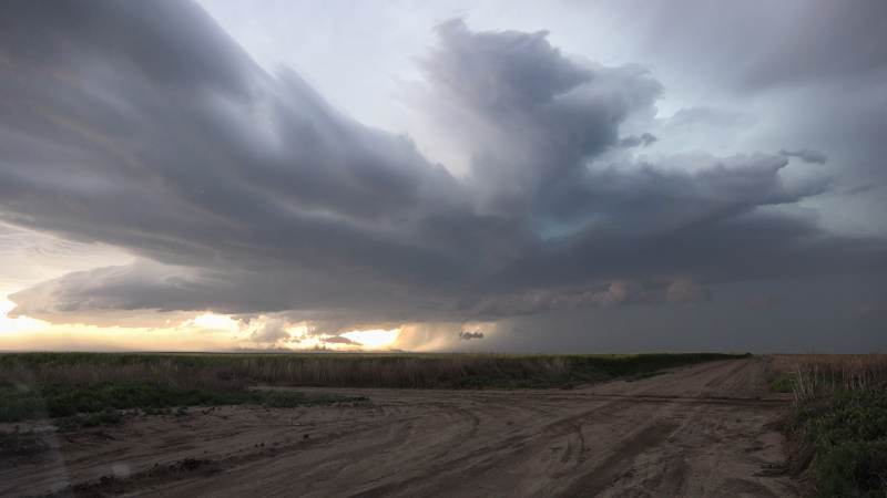
Marginal, low moisture play across eastern CO/western KS. Targeted ne CO for afternoon supercells noting weak dust whirl tornado near Idalia, CO followed by photogenic storms and outflow across western KS.

Crew and Equipment

Chase partners: Jennifer Brindley Ubl, Anton Seimon, Tracie Seimon. Equipment: Sony FDR-AX100.

Video

Map

Details

Thursday, May 25 was Brindley and my first day out on a multi-day run to the Plains chasing with Anton and Tracie Seimon. The first day looked incredibly marginal and conditional for any sort of tornado play with concerns about insufficient moisture and low level instability. The subpar parameters warranted SPC forecasters to not even issue a 2% probabilistic tornado forecast over the Plains, but a categorical slight risk for hail and wind damage. Storms were forecast to be high based and outflowy, but we wanted the extra shot since we’d be chasing in the area the following days anyway.

Team Woodchuck’s (Anton and Tracie) Forecast:

“Based on credible-looking guidance from the 12z NAM runs, our best play tomorrow may well be NW KS. This will be your call, but just wanted to let you know that we will add a time buffer here to our planning to ensure that we could make it to Goodland as a possible start point by 20z should this scenario indeed pan out.

Also, with -13 C predicted at 500 mb tomorrow over NW KS, upper-50s dewpoints should be more than sufficient to get the job done.”

Team Turtle’s (Skip and Jenn) Forecast:

“Per 12z guidance Turtle would still like to rendezvous in Sterling, CO. 12z NAM shows nw KS shut down for surface based storms. Despite HRRR and NAM NEST consensus that the top of the low/thermal axis will initiate in far eastern CO/nw KS with a prominent helicity track, this activity will most likely be elevated. No low level cap and LSIs are 3-5 C. I've never seen a supercellular tornado come out of such an environment. A landspout play might be possible, but would expect instead a high based and outflow storm instead. NAM shows 0-3km CAPE and open LSIs from Cheyenne southeast into ne CO through 21z. Steep low level lapse rates ahead of the advancing cold pool and we may get a surface based storm favorable for vorticity stretching. There's a wind shift draped along I-70 that I'm still watching closely as vorticity generator for us today. I'm also still watching if we need to adjust closer to Cheyenne to be better aligned for initiation rather than catching an outflow MCS as it advances into Sterling in the afternoon. Will watch as we head west on 80.”

Car Trouble
4 miles SSE of Percival, IA
9:09 PM
Brindley and I left the night before our chase, leaving early and taking our time so that we’d be well rested for the long drive out to Colorado and subsequent chase. After several hours on the road, we were dipping below a quarter tank so I planned to take the next fuel stop outside of Nebraska City. We didn’t make it. The car stalled just as it had done the previous times it failed this year. I tried restarting, this time cranking for 15-30 seconds and mashing the gas pedal down. It actually kicked over and I was able to get off the shoulder and lurchingly limp it to our exit and the gas station by keeping the gas pedal down. Topping it off, the pump indicated that about three gallons were still in the car when it died, making sense with the vehicle’s 80 miles of indicated range. The car ran fine once it had more gas in it, but the check engine light remained on and it seemed to be running a little rough.

Dinner of Champions
4 miles SSE of Percival, IA
10:27 PM
We got a room right next to the truck stop, not wanting to chance driving the car anymore that night. All the food joints were closed apart from the gas station convenience marts. We wound up eating microwaved potatoes with salsa in our tiny, dingy room outside of Nebraska City, NE. Storm chasing is glamorous.

The next morning we took the car into the Subaru dealer in Lincoln, NE. The check engine light was off, the error codes gone, and the car pretended as if nothing had happened. The dealer staff seemed worlds more attentive and helpful than the local dealer in Springfield. However, they couldn’t diagnose what was wrong with the car without spending a lot more time with it. We had to get on the road to our target area so we continued west with a gremlin prone Forester. It was becoming increasingly more clear that the problem was probably somewhere on the fuel line, and adding fuel seemed to be a workaround to getting the car going again. We'd have to carry extra gas with us from now on in addition to refueling before the car gets below a quarter tank. What a pain in the ass. I was starting to loathe my car.
Storms were ongoing by the time we made it into northeast Colorado, so we met up with Anton and Tracie mid chase. As expected, storms were high based and blasting outflow. Huge plumes were being kicked up ahead of the storms’ gust fronts.
Heading South out of Wray, we found ourselves racing a line of severe hailers. It was miles until the next paved east, and the north south line was on course to run us over. The textured updraft base spanned high overhead and glowing white curtains of hail loomed to the west. We shuffled into a small line of storm chasers, all of us blasting south to beat the hail. We didn’t make it and large stones started slamming into the ground all around and hitting the roof with deafening booms. I thought we were going to lose glass for sure, and some of the vehicles in the line did, but we made it out with all of our windows and the windshield intact.
Running east, we cleared the hail barrage and heavy rain after a few miles. In the chaotic scramble, we got separated from Anton and Tracie, who continued south and didn’t make our eastward turn out of Idalia, CO. There was a small dusty gustnado ongoing in the fields to our south and a nice pull off, so we decided to get off the highway and shoot it. Our friends with the College of DuPage were already there watching it, and we ran up to say hi.
The gustnado was remarkably well formed, persistent, and actually quite large for what is normally a small, transient whirl on the leading edge of the storm’s outflow.
We had been chatting it up with the COD folks so it took me a couple minutes for the surrounding structure to sink in. There was an occluded circulation in the storm’s updraft base above the debris cloud. It was sloppy and ill-formed at first, but now the green tinted cinnamon bun spiral was obvious. The precipitation core to the south was becoming more defined, the updraft base wrapping around it, and delineating the rear flank downdraft. We gradually realized we were looking at supercell structure, and that this was a weak tornado, not a gustnado.

Weak Tornado
24 miles SSE of Wray, CO
3:32 PM
We had a shot of the tornado for well over five minutes before the debris cloud started to fade.
The The occluded circulation in the storm’s base persisted, wrapped in streaky bands of rain from the rear flank downdraft. It looked like an inflow jet was feeding off the forward flank as well.
We pursued the cell and others into Kansas. That was it for the tornado show, but we had gorgeous and dramatic skies for the entire rest of the chase.
Rear flank gust front and an attempt at a block wall cloud:
Blue core and outflow:
The wave pattern of Kelvin-Helmholtz instability in the storm’s dusty outflow:
Team Woodchuck:
We called the chase near sunset and headed into Colby, KS for the night.

Conclusion

It wasn’t a significant tornado, but the catch greatly exceeded our expectations. The marginal moisture and parameters no doubt led to its high based, relatively weak, and funnel cloudless nature. We hoped this was just the preshow too, with bigger events forecast in the following days.

Lessons Learned


Follow On The Web!
Storm Chasers Giving Back!

Webpage, graphics, photos, and videos © Skip Talbot or respective owner 2018.
skip.talbot@gmail.com Skip's Webzone