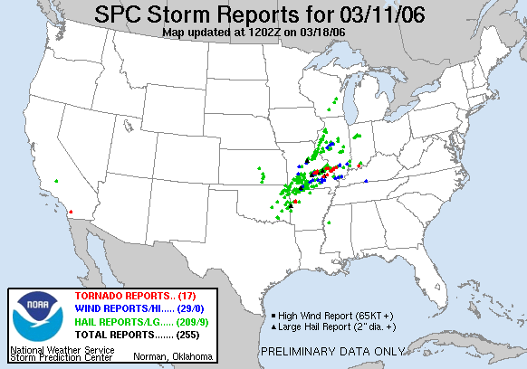
Statistics:
| Initial Target: | Jacksonville, IL |
| Departure: | Bolingbrook, IL 10:00 am CDT |
| Arrival: | Bolingbrook, IL 10:30 pm CDT |
| Intercepts: | Rushville, IL |
| Tornadoes: | 0 |
| Hail: | Severe (1 inch estimated) |
| Wind: | Non-Severe (not measured) |
| Features: | Rotating wall cloud |
| Miles: | 530.0 |
Summary:
| Left Bolingbrook with Fabian Guerra, targeting best instability and shear combination on east side of MS river. Met Jerry Funfsinn in Bloomington and chaser convergence in Jacksonville and waited until initiation near Hannibal, MO. Intercepted high based RFB northeast of Rushville, until falling back on another storm with a large wall cloud. Moved underneath wall cloud and observed strong rotation until core started dropping quarter sized hail. Blasted ahead of the storm and called it a chase as cells congealed into a line. |
Crew and Equipment:
| Chase team included Fabian Guerra. Equipment consisted of a TH-F6A Tribander, and GPS/Cell Phone equipped laptop. Photography by Skip Talbot. |
Details:
| This system looked promising a week out on the models and I was following it very closely from run to run. A strong low pressure center moving through Iowa was to advect dewpoints into the 60's throughout central IL. Surface temps were expected to be in the upper 60's. Strong speed shear and backed surface winds indicated the potential for supercells with a tornado threat. SPC initially went with a slight risk, using their new 10% tornado probability, but upgraded to a moderate risk up through Illinois later in the day. |
 |
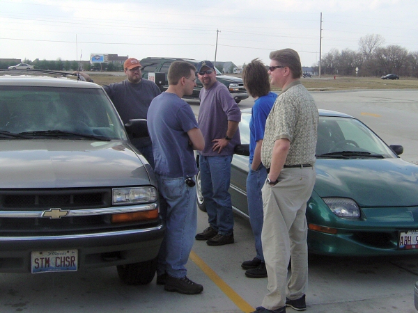
| Fabian Guerra and I agreed to team up for the chase. We met up at my house, checking the models one last time before hitting the road. We stopped in Bloomington for gas and data. Jerry Funfsinn was just behind us on 55 so he met up with us. We all agreed on heading out towards the Jacksonville area after analyzing the RUC. | |
| Mark, Scott, and Darin were already at our favorite data stop: Jacksonville's Comfort Inn. We were toying with the idea of heading further west or possible south, but forecast soundings looked great over Jacksonville so we hung around for a couple hours waiting for initiation. |
 |
| A band of weak showers right on the MO river jumped to 30 dbz on our radar in the next scan. Initiation, and the chase was on! Our three vehicle caravan raced west on 72. There was some dispute about which north option to take for the intercept. The weather seal had popped out of my window, preventing me from rolling it up. The wind noise made the ham radio impossible to hear so our caravan split, Mark, Scott, and Darin taking an earlier exit. Jerry, Fabian, and I exited on 107 and soon had a low topped storm in our sights. |
 |
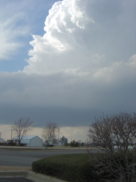
| I stopped for a shot of the crisp convection and RFB while
we plotted our intercept course. 24 became our road of choice on this
chase, flanking the cells to the south. We stopped in Rushville to analyze the radar. Our storm was ahead of a line, looked strong with a nice discrete structure and looked like it was starting to take on the characteristic pendant shaped. We went for it. |
 |
| Our cell was warned, severe or tornado, I don't remember as
I tried to navigate through the small towns. Fabian informed me that a
firefighter had tried to wave me over to talk, but I didn't see him.
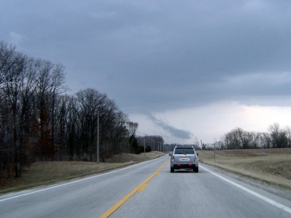
We didn't really have time to chat anyway. Outside of town we found a
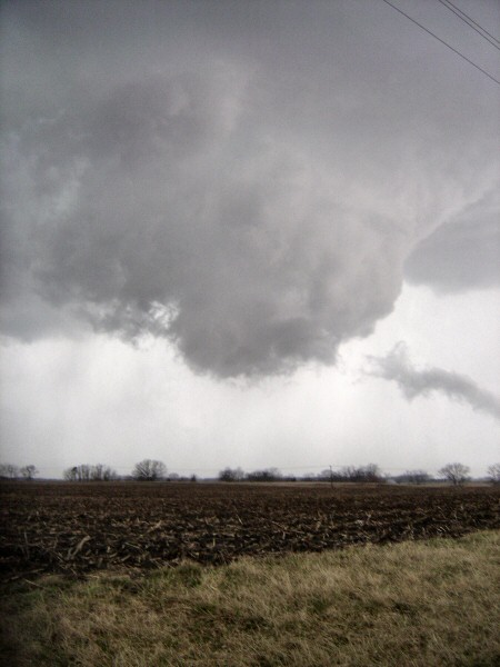
nice quiet road right under the RFB of our storm. It was high based. Notice the smoke-nado in the distance on the left side of this picture. |
 |
| There was a sharp distinction between the RFB and the precip core. The high based storm showed no sign of producing a lowering though and the precip core looked more like thin veils of rain rather than a severe core. We watched the storm for at least 15 minutes before we got a call from Darin. For twenty minutes they been watching a storm just west of us that had a large wall cloud under it. We abandoned our storm. |
 |
| We raced back west on 24. On the way we saw this scud-nado form, the kind that can trigger a false report (image if the base of that were obscured by trees). Just before we hit Rushville the wall cloud came into view. A large wall cloud it certainly was, very broad and low to the ground with a well defined tail cloud. (I was unable to shoot stills of during the intercept. Fabian has video which I will post when I obtain a copy of it). |
 |
| In Rushville we temporarily lost sight of the wall cloud. We also lost Jerry. I turned us north out of town and parked us in a spot with good visibility. I had also inadvertently managed to park us right under the wall cloud. Looking southwest at the northern tip of the wall cloud. The base was tightening up. |
 |
| The storm was moving northeast directly over our heads
The nub on the end of the wall was rotating strongly. Having a large
rotating cloud mass moving directly towards you always puts a few
butterflies in your stomach. Fabian commented that if the feature were
any lower we'd be booking it out of there. Needless to say, our
positioning under this storm could have been better.
Fabian shot video of the feature, capturing the rotation, while I shot a few stills. Although his camera was pointed up, Fabian admitted he was watching the ground for a debris cloud. |
 |
| Just before the rotating lowering passed overhead, the downdraft hit, cold and wet. We packed our stuff up and got in the car to stay ahead of it. With perfect timing, the hail started just as we started to move. The stones got up to quarter size and I managed to get the S word on the video (its a severe hail tradition). We raced east on narrow and unpaved county roads, faster than one would comfortably travel on them under normal conditions. We beat the hail and by coincidence spotted Jerry up ahead. I shouted to him warning about the hail on the way intending that we keep moving. However, our little run east allowed the storms to move far enough north to remove us from the path of the core. We watched our wall cloud with tight rotation disappear into the precip core, and that marked the conclusion of our chase. | |
| We took 24 all the way to 55 up by Chenoa. I opted against I-74 because I didn't want to get caught in the construction that plagues that area. There is no escaping the clutches of Peoria, however. An accident trapped us on a bridge and we were stuck in Peoria for over an hour waiting for the wreck to be cleared. |
 |
|
|
|
| Conclusion: Our initial storm had pretty much died after we left it. The storm with our wall cloud congealed into a large line, with no tornado reports coming in. The tornado activity turned out to be further south. A great start to the year. We had bagged ourselves a large rotating wall cloud and severe hail, not bad for a pre season chase. Compared to 2005, the first chase of the season was better in 2006 and came more than two weeks earlier. The next days chase, however, would shadow March 11. Lessons Learned:
|
|
|
|
|