
Statistics:
| Initial Target: | Rensselear, IN |
| Departure: | Westchester, IL 7:00 am CDT |
| Arrival: | Westchester, IL 10:30 am CDT |
| Intercepts: | Rensselear, IN |
| Tornadoes: | 0 |
| Hail: | Non-Severe (not measured) |
| Wind: | Non-Severe (not measured) |
| Features: | None |
| Miles: | 231 |
Summary:
| Extreme shear, low instability cold front play across eastern IL and western IN. Targeted northwestern IN for fast moving line of storms moving into Indiana just after dawn. Intercepted tornado warned cells north of Rensselear noting fast moving clouds but little storm structure. Called off chase after falling behind fast moving line, stopping for gas in North Judson with the sirens blaring. |
Crew and Equipment:
Solo chase. Equipment: Kenwood TH-F6A Tribander, Dell Inspiron Laptop. Kyocera data card and router, Holux 236 GPS, Robotic camera dome with Sony XR-520V.
|
Details:
| Tuesday's setup was marked by a record setting low pressure system. A low tracking through Minnesota was forecast to bomb out at less than 960 mb. A 100+ knot midlevel jet was forecast to eject across the Ohio river valley with a fast moving cold front at the surface. This extremely dynamic system featured extreme wind shear and the potential for a wind spread damaging wind event. SPC upgraded to a high risk on the day 1 for damaging winds as a result. |
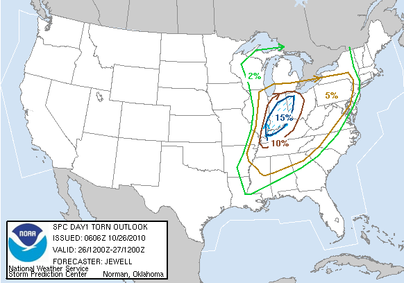 |
The warm air advection, extreme shear, and dramatic height falls also posed a threat for a possible tornado outbreak, despite the forecasted lack of instability. Given the record setting parameters of this system, I decided to chase it, even knowing that the potential for catching a tornado or even a storm with a decent view in such a highly sheared, low instability setup would be difficult. Anything can happen with such extreme parameters, and I didn't want to miss would could be a historic outbreak and one close to home. Storms initiated at about 9:30 pm the night before, well ahead of the cold front in central Missouri. The Storm Prediction Center was quick to put up tornado watches as the cells were initiating in an extreme environment with over 50 knots 1 km shear and 750 1 km srh. Such, extreme low level shear could make low topped storms into tornadic supercells that would normally be too small to produce tornadoes. Given the lack of lightning on these smalls storms and their high speed, I decided to wait until dawn when I had some light before heading out to chase them. I was up and out of the house before dawn at about a quarter to seven. The lines was already starting to move through the Chicago suburbs with light rain first, and the stronger cells on the very back edge and clear immediately following. The bombing low created some very gusty winds, which I had to contend with as well as the rain and morning rush hour as I navigated out of the suburbs. I headed down 80 east into Indiana and then south on 65, getting ahead of the line and heading for some more discrete cells moving in western Indiana. A tornado warning went up for Kankakee and Will counties back in Illinois. I thought doubling back and trying to intercept, but I could not make out anything discrete on the radar, and the circulation, if there was one, would be well into the suburbs by the time I got there so I continued going south for the more discrete cells. These soon became tornado warned as well, and I intercepted north of Rensselear. There was very little structure to see in these storms, just a bunch of fast moving gray clouds. This is about what I expected from a high shear/low instability setup. I followed back end of the line as best as I could, which had the best visibility as there was no precipitation behind the cells. I finally started to fall behind and headed toward North Judson to get some gas and head back home. I came up a fallen tree that was probably a result of some straight line winds. While I was gassing up in town, the sirens went off. A new tornado warning had been issued just to the northeast of town, and even though the town was outside of the warning polygon, and the line of cells was well off to the east, apparently the siren sounders thought the warning included them. Perhaps sirens across the whole county sounded, but with light cumulus blowing overhead and the threat long gone, it was obviously a false alarm for this town. |
|
I snaked my way back up to 80 and headed west, making it back home by 10:30 am. This was probably a record time for me to end a chase that hadn't been aborted.
|
|
| Conclusion:
This storm system was historic, setting low pressure records. The high risk was definitely warranted for the wind damage reports that came in. Many tornadoes were also reported across the risk areas including tornadoes near Peotone, IL and Valparaiso, IN, not too far from where I was chasing. I came home empty handed, not having shot a single picture. This chase was a bust as I witnessed nothing more than some fast moving shower, but that's pretty much what I expected given the setup. However, it was worth the slim shot at seeing something amazing on a day with extreme parameters where anything could have happened.
|
|
|
Lessons Learned:
|
|
|
|
|

