May 7, 2014

Statistics

Initial Target
Start
End
Storm Intercepts
Tornadoes
Hail
Wind
Features
Miles
Blue Earth, MN
Springfield, IL 9:37 AM 5/7/2014
Mankato, MN 10:41 PM 5/7/2014
Madelia, MN
0
0"
0 mph
Updraft Base
549

Summary

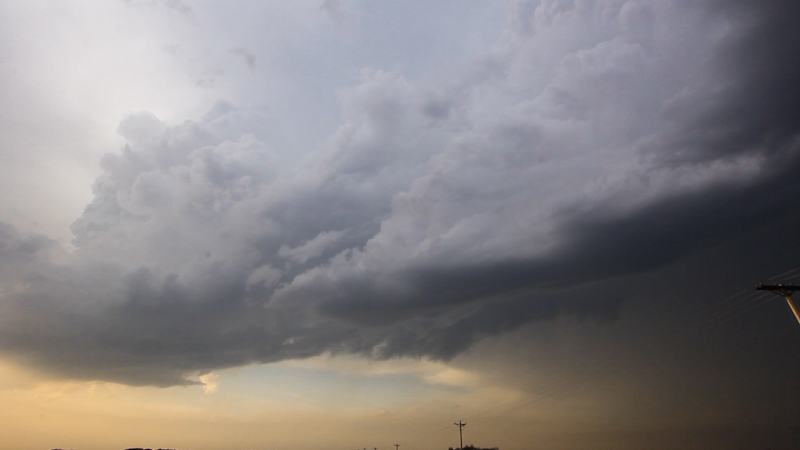
Day before the day warm front play across southern Minnesota. Targeted the Blue Earth, MN area for afternoon/evening supercells. Caught developing severe warned storm near Madelia, MN noting updraft base, but small cell didn't organize much past low end severe limits and became elevated north of the warm front before shriveling into an orphan anvil. Dinner and spent night in Mankato.

Crew and Equipment

Solo chase. Equipment: Canon 60D, Canon t2i, Canon EFS 10-22, Canon EF 50mm, Sony HDR-xr500v..

Video

Map

Details

I had a chance at a day before the day play in Minnesota and it looked pretty decent to me, despite the rather low tornado probabilities issued by the Storm Prediction Center. A warm front was draped across southern Minnesota, and storms looked to initiate off the dryline/warm front triple point. Favorable shear profiles but modest instability made smaller supercells or perhaps a tornado possible. The next day's setup looked to be over the same area so I decided to head up there a day early and see what I could catch. My usual chase partner, Brindley, had a shoot so I was solo for this run.

Awaiting Initiation
1 miles N of Blue Earth, MN
6:25 PM
I setup in Blue Earth, MN as a mesoscale discussion went up and cumulus started bubbling to the west.

Storm Initiation
5 miles SE of Winnebago, MN
6:30 PM
Cells fired just to my west and I watches as they matured into severe warned thunderstorms. As they moved north of Blue Earth I decided to move in for the intercept.

Updraft Base
3 miles NE of Madelia, MN
7:18 PM
A small low precipitation (LP) updraft base came into view. The modest size storm already appeared to have crossed the warm front, so it probably wasn't going to produce a tornado, but it was pretty in the evening light and worth tracking for awhile.
I watched the small cell pass to my north, just east of Madelia, as the updraft base appeared to shrivel.

Dying Storm
3 miles NE of Madelia, MN
7:40 PM
Deprived of good instability north of the warm front and without much dynamic forcing, the storm started to die, shriveling up into an orphan anvil. I watched it drift off to the north before heading into to Mankato to get some dinner. I met up with Rob Hurkes and James Seitz at a Chinese Buffet and we had a good time telling stories and talking about the chase as an MCS raged outside with thunder and small hail.
Solo and saving money, I camped in the van just west of town, where I'd be in good position for the following day's setup.

Conclusion

These day before the day setups can be great chases or they can be complete busts, and it's nice to get an extra chase out of a long trip. Ultimately this chase was a bust, despite the pretty sunset storm. The lack of good supercell structure was lackluster for a trip to Minnesota, but it was still an enjoyable outing and it was great chatting with Rob and James over dinner later.

Lessons Learned


Follow On The Web!
Storm Chasers Giving Back!

Webpage, graphics, photos, and videos © Skip Talbot or respective owner 2018.
skip.talbot@gmail.com Skip's Webzone