June 16, 2014
Statistics
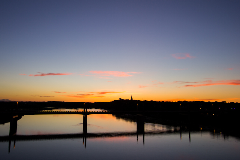
Yankton, SD 9:24 AM 6/16/2014
Sioux City, IA 9:19 PM 6/16/2014
Concurrent violent tornadoes, wedge, satellite, funnels, RFD clear slot, shelf cloud
Summary
Dryline/warm front setup over IA/SD Sioux area. Targeted warm front along I-90 in e SD for afternoon tornadic supercells. Intercepted severe warned linear MCS in morning with dramatic shelf clouds and lightning. Retargeted developing supercell in ne NE. Documented two concurrent, violent tornadoes ne of Pilger, NE, satellite orbiting developing violent, wedge tornado south of Wakefield, NE. Several funnels and decaying udpraft tower sw of Sioux City, IA. Dramatic updraft bases and scud at dusk over Sioux City followed by intense MCS.
Crew and Equipment
Chase partners: Jennifer Brindley Ubl, Phil Bates. Equipment: Canon 60D, Canon t2i, Canon EFS 10-22, Canon EF 50mm, Sony HDR-xr500v..
Video
Map
Details
This is the story of my greatest and most intense storm chasing adventure since 2010. Jennifer Brindley Ubl, Phil Bates, and I were on an extended trip chasing storms across the northern plains. We awoke on Monday, June 16, in Yankton, South Dakota at the Riverfront Hotel, a newly remodeled hotel in an ancient building right on the Missouri River. A quirky local place with tons of character, it was just our style. The previous day was spent shooting clouds and sunsets, relaxing on patios with drinks, going for walks in parks and watching movies. The tone was completely different on Monday, however. It was a big chase day. We were anxious and excited to get out there having yet to get a photogenic tornado on the trip. The forecast was ominous. A strong to extremely unstable airmass was forecast across the Sioux region with a warm front extending along I-90 and a dryline draped down into eastern Nebraska. A strong southerly low level jet, moderate southwest flow aloft and backed (southeast) surface winds made for great shear profiles. The ingredients were there for tornadoes.
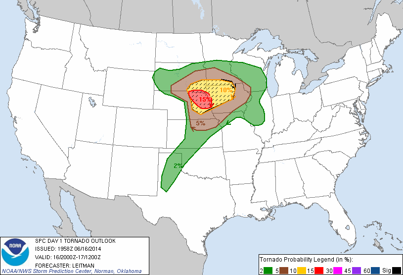
Ironically, Monday’s chase wasn’t even part of our original itinerary for the chase trip. Early forecast models made it appear that the weather was going to dry up after the weekend, as a cold front was forecast to push through and the trough eject. We were going to head home, but decided we wanted more time in the Badlands and Black Hills, so we decided to extend the trip a couple days to do some sightseeing across South Dakota. As Monday approached, however, the weather models started to change their tunes. The NAM model was plotting instability values as measured by CAPE exceeding 5,000 to 6,000 J/Kg, an extremely explosive environment. The shear wasn’t quite there with rather weak flow aloft, but with that kind of instability, storms can create their own shear with deviant motion and powerful updrafts. All bets were off and anything is possible with extreme instability. We decided to chase the event instead. The night before the event, the NAM picked up on the strong low level jet. Storm relative helicity was forecast to exceed 800 m2/s2. The tornado parameters were off the charts. Huge and violent tornadoes are possible with that kind of shear and instability combination, however, only if discrete supercells could be maintained. If the capping inversion, the lid on the atmosphere, is too weak, the atmosphere could blow up too early in a huge mess of rain, or if it’s too strong it could stifle storms completely. It looked like we might face challenges from both ends of the cap, with a warm front socked in with junky convection, and a capped warm sector to the south. Forecasting a storm chase is almost never a slam dunk. The Storm Prediction Center was on top of the event, mentioning supercells with potentially violent tornadoes. By the 3pm outlook as the show was about to erupt across northeast Nebraska, the region was upgraded to a moderate risk.
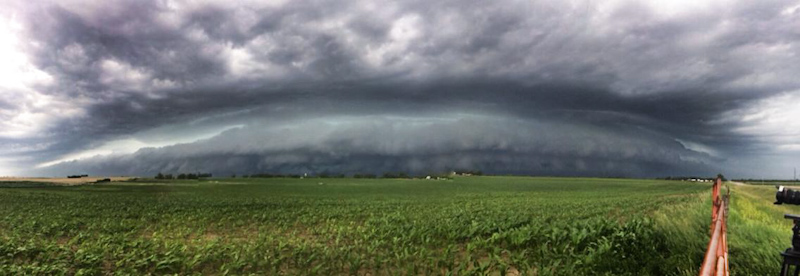
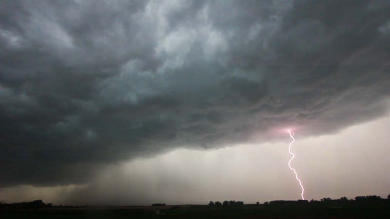
But I’m a sucker for the warm front. I wanted to play the better directional shear, open cap, and lower LCLs to the north, so I set our initial target along I-90 in southeast South Dakota. We were rolling north of Yankton by 9am, stopping at the Subway for both breakfast and lunch sandwiches. We had a minor crisis in the van, however, when I accidentally ate Brindley’s sandwich instead of mine, but it was averted with another stop at the next Subway north of Yankton. Elevated showers were going up overhead, tracking northeast rapidly. We hoped they would clear the warm sector as the lowest levels of the atmosphere had yet to warm enough to support surface based supercells and tornadoes. Meanwhile, a severe warned, linear MCS was tracking east just north of 90. It didn’t have much of a tornado potential, but we figured we could get some dramatic shelf cloud shots before dropping south for the afternoon play. We headed west down 90 toward Spencer, and then north, stopping just south of the apex of the bowing line of storms and letting it come to us. A panoramic of the line:
The leading edge of the shelf passing to our north:
A “selfie” in front of a shelf cloud is called a “shelfie”.
“What The Duck” even made an appearance for a few photos in front of the shelf cloud (while also managing to photobomb my time lapse).
Phil was able to shoot some spectacular shots with his IMAX quality Red camera including time lapse of the approaching shelf, and swirling, roiling motion in the blue-green cloud bases.
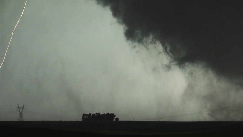
As the line approached we could see a terrific amount of cloud to ground lightning. One spot in particular appeared to be spitting out bolt after bolt. CG strikes were coming at a frequency of one per 3-4 seconds at times. It was much more than I expected from an elevated morning MCS. The lightning wasn’t hitting close, staying mainly in the rain, but it still had us on guard, and as the rain approached so did the lightning. One close strike rattled us and made Brindley and I retreat to the van. “I felt that one in my teeth!” she exclaimed.
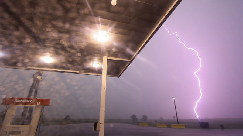
Before the line engulfed us, we headed south, back to the interstate. We stopped at a gas station to top off and see what our next play might be. The gust front of the MCS looked like it was going to engulf the remainer of the South Dakota target, while storms to our east would remain largely elevated. The storm hit while we waited at the station. Torrential sheets of rain propelled east by howling winds rocked the van. Phil ran into the station to charge some of his gear and cars from the interstate piled in under the canopy to get out from the storm. Lightning struck all around us with piercing cracks of thunder, and one bolt momentarily knocked the power out.
A green blip appeared on the radar in northeast Nebraska near Norfolk. I pulled away from the canopy to clear the pump, the storm starting to taper down. I checked the parameters where the tiny radar return was located. The environment was primed. A couple scans later and we realized we had our storm and not a transient shower as the radar echoes continued to grow. We should have moved immediately on the development. We only delayed by about 10-15 minutes, but the time lost dramatically influenced how and where we would intercept the storm. With Phil back in the van, we started making a mad dash south for the developing storm, as fast as we could reasonably and safely go. We took a few side roads to get out from underneath the MCS before running south on 81 to Yankton. I couldn’t hold it any longer and pulled off to pee on the side of the road just north of town. Another delay, and moments counted. Traffic was heavy through Yankton and we crept through the town and several traffic lights. Once across the river and into Nebraska we cleared the morning MCS gust front and whale’s mouth and were under sunny, soupy skies, thick with moisture. The atmosphere was unbearably warm and muggy, creating our extreme instability. Which route should we take though, direct on US 81 getting there fast but coming in behind the storm, or running east to get ahead of it first? We opted for 12 running east along the river, and then south through Wayne.
We passed several cars, pushing our speed. It looked as if we still had time to spare. The updrafts hadn’t consolidated into a single, dominant supercell yet. I was wrong, however, and there were multiple updrafts with powerful mesocyclones already in progress. The complex went tornado warned and a report of a large, wedge tornado rapidly followed. We were missing the show, and I gritted my teeth, desperate to get us down there. Running south into Wayne we started to get into the northern edge of the storm’s precipitation. Crisis hit in the van. The GPS went out. We had turns coming up, no visibility on the storm’s structure or tornado’s position, and now no navigation support. It was a tense couple minutes as I directed Brindley on how to reset the GPS, while negotiating traffic in town. At the main intersection in town we had one last critical decision to make. Do we move in for the intercept now, with a direct core punch heading south, or cut east first and get ahead of the storm? With a violent wedge being reported on the storm, what would later be known as the Stanton EF4, I decided that a south core punch would be too dangerous given our proximity. We drove east through Wayne to get to our next south option. Traffic and the rain were heavy through town. The residents were no doubt rattled as the town had taken a hit from an EF4 the previous fall, and were now again being side swiped by a massive tornado producing supercell.
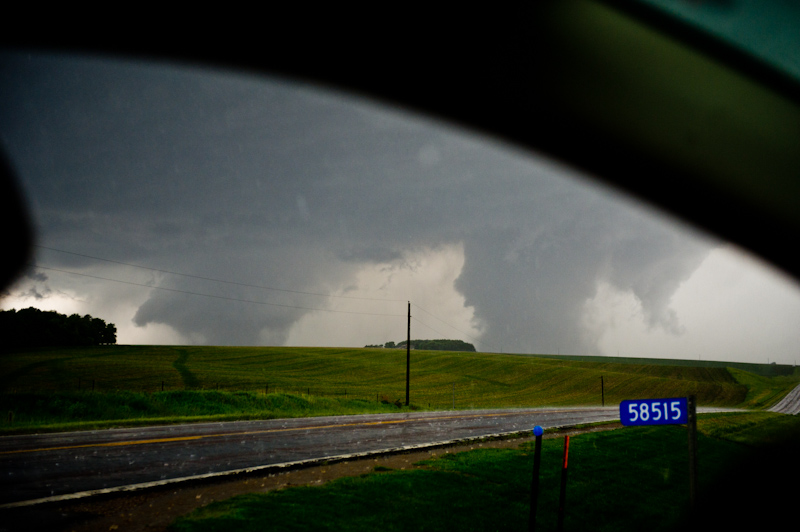
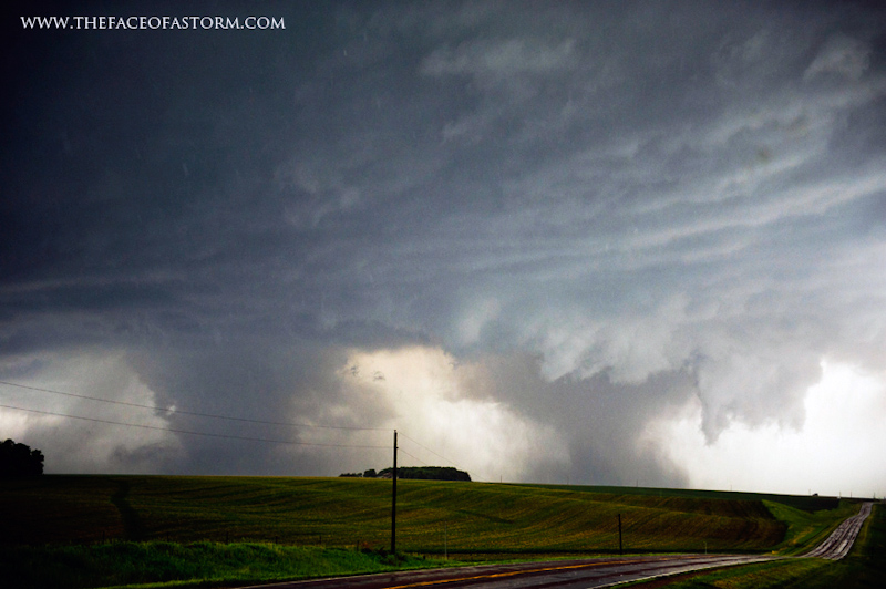
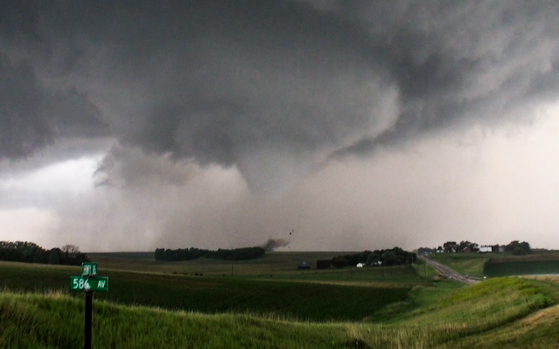
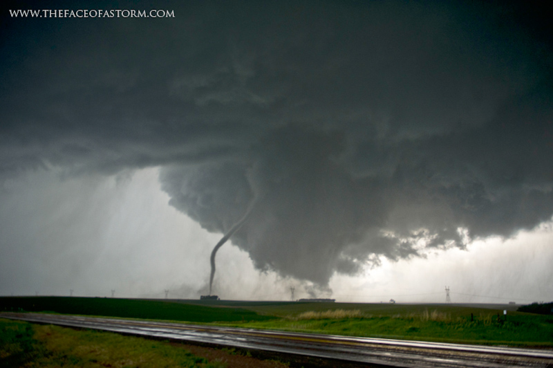
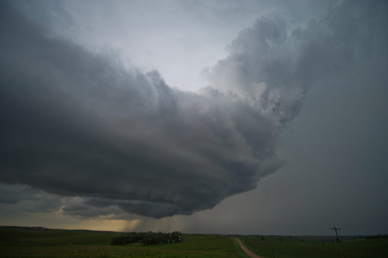
We cleared the town and were rolling east. A single car ahead of us was the last of the traffic, tooling around at slow speeds in the heavy precipitation. We went for the pass, probably looking like lunatics as we raced through the storm. We turned south on 16. We were all alone now, having left the last of the traffic miles behind us. The sky to the south was ominously dark, and being the only ones out there was giving us creepy vibes. Brindley was starting to get jumpy. We pushed deep into the core of the storm. The rain picked up and then the hail began, pinging off the van with “dings” and “donks.” Another mile south, and we still had zero visual on storm structure. We pushed on, taking the van as fast we could safely go in the conditions, hoping to beat the storm and tornado before it crossed our route. Another couple miles, and we started getting really anxious. We should see the base by now, and I was worried the tornado had occluded and moved into the forward core and become completely rain wrapped, an incredibly dangerous situation to encounter that I had hoped to avoid by going east first. Another mile and the southern horizon started to lighten, and the faint form of the storm’s updraft tower and base started to appear through the pouring rain and hail. “Thank God!” Brindley exclaimed in relief. We cleared a hill and a tree line. The base of the storm dipped making it appear that the storm was dragging on the ground. “Yep, we’ve got a wedge!” Brindley shouted. “It’s huge!” From the driver’s seat I couldn’t closely monitor the tornado, so I relied on Brindley for guidance on its position and our safety. I wanted to keep heading south, but the road looked like it went to gravel ahead. “Are we in the path still?” Brindley looked at the huge, looming wedge tornado which appeared to smother the southwest sky with epic proportions. There were actually two large tornadoes in progress, which we didn’t know at the time, but they lined up and appeared as one due to the low visibility at our position. Slate grey, featureless storm spanned overhead, tapering down to a tornado that appeared to be miles wide. The epic mass towered over us and seemed to be rolling toward us. “Wow, we’re definitely in the path!” Panic was creeping into Brindley’s voice. Since our harrowing, and life changing encounter with the tragic El Reno tornado that killed our colleagues and friends, Brindley and I have both been instilled with deep respect for tornadoes and a fear that keeps us safe. Brindley especially, who is the first to alert us to danger and get us moving to safety, and everything about our position was telling her that we needed to flee.
Without delay we followed 16 as it turned east to get a couple miles ahead of the storm. There was a driveway at the top of a hill and I pulled into it to get our bearings, and see if we were still in the path. We watched the low contrast mass of tornado through the rain and as it approached, its form started to take shape. “That looks like two wedge tornadoes.” “It does!” I replied to Brindley. Two tornadoes emerged from the rain. I stared in disbelief. Brindley was completely dazed and I had to remind her to take pictures. She stepped out into the rain to shoot them, and standing downstream of two large tornadoes was breathless with awe. Overwhelmed, she still wanted to put ground on the tornadoes and execute an escape route. Meanwhile, Phil was scrambling to get his Red camera and tripod ready. Fixated on getting the shot, he almost seemed lost in the moment, ignoring Brindley’s urging that we had to go. I was trying to keep the van sane and on an even keel between people wanting to stay or flee. The tornadoes appeared to still be a few miles away so we had minutes yet, and after watching them for a few moments, both appeared to be tracking to the right slightly, which would put them on a course to eventually pass to our north. We were safe for the moment.
As the rain started to move off to the north, the contrast increased dramatically. Looking straight up, I could see the updraft tower of the storm extending far overhead. The storm’s base and mesocyclone wasn’t even over us yet. This reassured Brindley that we had some time yet, and we continued to watch the tornadoes to make sure that we remained clear of the path.
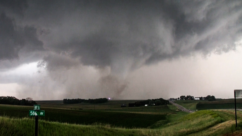
The sight was like nothing I had seen before. I’ve seen two concurrent tornadoes before, but it was always a smaller rope satellite orbiting a larger tornado, or the decaying stage of one tornado and the initial developing phase of another on a cyclic supercell. It looked like there were dueling mesocyclones on this storm, however, with two mature, violent looking tornadoes on a parallel course. The scene reminded me of the 1965 Palm Sunday tornado, in which a famous photograph showed what appeared to be two large tornadoes in close proximity. I always thought that tornado was one wedge undergoing a process known as vortex breakdown. This was different, clearly two independent tornadoes. We didn’t know it at the time, but the tornado on the right had just devastated the tiny town of Pilger, Nebraska, the core of the vortex going right through the center of town. The tornado would be known as the Pilger EF4. Its twin on the left stayed over mostly open terrain, but inflicted EF4 damage as well: the East Pilger EF4. The storm had produced three violent tornadoes in a short amount of time. It was far from done, however.
Phil was moving between the trunk and the sliding door, getting his camera and tripod setup. Meanwhile, an intense barrage of positively charged cloud to ground lightning bolts had begun. Positively charged “superbolts” as they have been called can be 10 times stronger than the much more common negatively charged bolts, last longer in duration, originate from much higher up in the atmosphere, and are incredibly dangerous. The lightning channel is smooth without the jagged branching, and the thunder sounds like one giant mortar blast that you feel in your chest, rather than the extended crackling and rolling rumbles. “Keep your feet in the van,” I told Phil. Staying inside your vehicle minimizes the chances of getting struck, as the current is usually conducted around the car’s steel body. The positive CG barrage was unusual to me. Such a display is often the precursor to tornado development, and not something I’ve seen during a tornado show. I couldn’t fathom that it was indeed still a precursor.
Crisis hit the van again. “I can’t get my camera to work,” Phil announced in despair. Phil had been trying for over four years, after many failed storm chasing attempts, to get a dramatic shot of a tornado with the Red. Now, presented with what might be a once in a lifetime opportunity in scale and rareness, his camera’s touch screen refused to take any input. The tone in Phil’s voice sounded like he was almost on the verge of tears. It was heartbreaking to hear. Brindley wanted to move, and again trying to keep the van sane I tried to calm everyone down, reassuring them that we were still clear of the path, and offering some towels to Phil to dry off the rain splattered touch screen, and that he should take his time and focus on getting the camera running rather than giving up in despair. I yanked my camcorder out of the dome enclosure on the roof of the van and shot handheld through the driver’s window so at least somebody could get a clean video shot of the tornadoes, while Phil worked on his camera, and Brindley was stuck shooting stills over my shoulder.
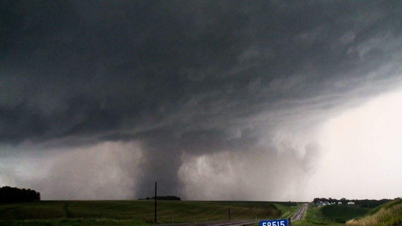
We lost sight of the Pilger EF4. We didn’t see it dissipate. Instead it looked like it had been merely enveloped by rain. Perhaps the condensation funnel had dissolved, but the rainy mass no doubt still contained a damaging circulation of wind at the ground. The East Pilger tornado was taking on a fat barrel shape and looked like it was becoming the dominant circulation. Meanwhile, the inflow winds picked up dramatically at our location, rocking the van. They were so strong I was worried that something like a tree or power pole could come down on us if we were haphazardly parked, but we appeared to be clear of obstacles. The winds were another ominous precursor. Meanwhile, Phil had managed to get his touch screen cleaned off, the camera rebooted, and he was rolling with a lap steadied shot from within the van.
The East Pilger tornado looked like it was beginning to rope out and also being enveloped by rain. The rotating base of the storm was now moving overhand, but the one visible tornado was still tracking to the right and our north so I thought we were still out of harm’s way. Then I finally saw it, the source of the subtle precursors I had noticed earlier. A dip in the base of the storm to our south-southwest, was now taking on the shape of a distinct bowl funnel. It was much closer than the roping out tornado, and we appeared to be immediately downstream of it. I watched it for a couple moments to see if we were in the direct path. There was no perceivable left or right motion in the short time I watched it. We were in the path, or dangerously close to it. We had to execute our escape route immediately.
We scrambled to get tripods back in the van and the doors shut and then were rolling down 16 east away from what was a developing a tornado.
Behind us, I could see the East Pilger tornado roping out, sweeping forward and back. It reminded me of the tornado in the “Wizard of Oz.”
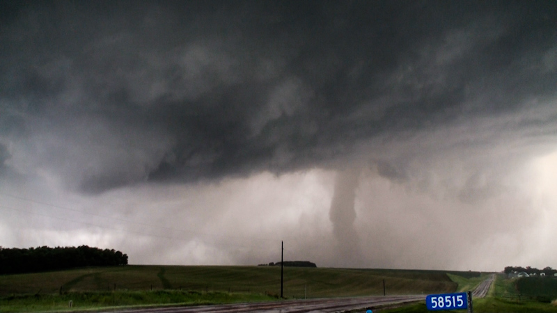
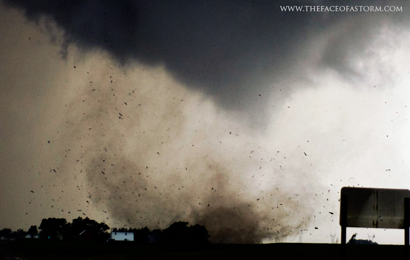
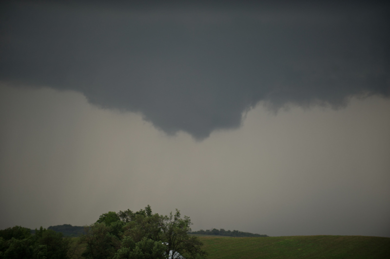
We stopped at the next intersection atop a hill, about a mile. I didn’t know if we were clear of danger but wanted to get my bearings. Getting out of the van I could see clear air overhead and that we had more than cleared the path of the developing tornado. A well-defined cone funnel was extending from the tornado cyclone. I had barely enough time to get the camera enclosure open and cameras aimed before a large plume of dirt and debris was lofted into the air.
Two bright flashes as the fledgling tornado struck power lines.
A wide angle shot showing the exquisite cinnabon-like swirl of the tornado cyclone with cone funnel and tornado debris cloud underneath.
The debris cloud tracked just west of the house where we had been parked. We could see it between the house and the next hill less than a mile from there. We would have been on the edge of and dangerously close to the tornado had we stayed at that position.
The funnel had yet to descend all the way to ground, but the debris cloud indicated that a powerful tornado was in progress.
It hit something and the air became filled with debris.
The rushing, waterfall like noise of the tornado was distinctly audible at this point.
A corkscrewing tendril kicked up on the back end of the debris cloud. It was a suction vortex of what was now a multiple vortex tornado.
A moment of triumph as a dream is realized. For years, Phil had been working to get this shot: a high contrast, dramatic tornado at close range in 5k resolution. Here it was finally, in all of its glory. The tornado had likely impacted structures, but from our vantage it appeared to be tracking relatively harmlessly across open terrain. We were alone, witnessing this epic force of nature in a remote corner of rural Nebraska, and we celebrated the moment.
A close up of the debris cloud:
I was amazed and perplexed at how little traffic there had been. On what was likely going to be the biggest chase event of the year, we had yet to see another chaser. Just a couple of cars had passed by, likely local traffic.
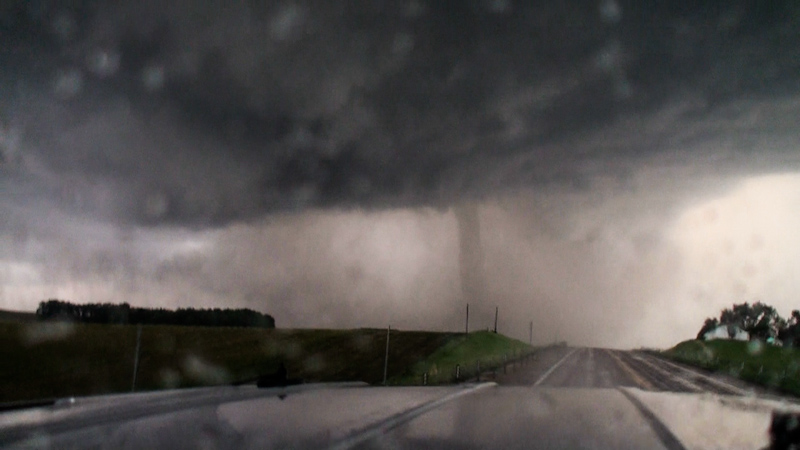
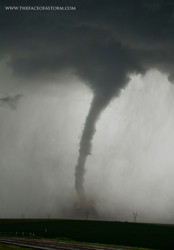
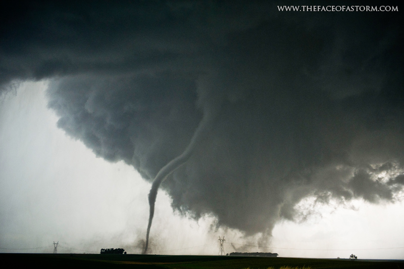
The tornado was now displaying very prominent, classic multiple vortex structure, which is often a precursor to the entire condensation funnel filling in and becoming a violent, wedge tornado. To the left, off frame, and for only a moment, a tall, snaky rope satellite tornado was visible. It was low contrast, and vanished back into the rain before anyone had a clear shot of it.
A lowering with modest rotation was forming directly overhead. I watched it, but it didn’t appear to be a threat. Then the satellite reappeared, emerging from the rain as a tall stovepipe tornado.
We were stunned by the display: a tall stovepipe next to a large multiple vortex tornado.
The satellite tornado twisted, with a knobby, turbulent condensation funnel and large dusty debris cloud. It appeared to hold stationary for a few moments before moving east toward the larger multiple vortex.
Then a positively charged bolt of cloud to ground lightning struck between the tornadoes, piercing through the tornado cyclone of the multi vortex and illuminating both. The moment was one of the most epic sights I have ever witnessed. The scale and awesomeness of the scene made it appear as if there were two monsters of mythical proportions doing battle in the sky. Like Godzilla versus the Muto, firing bolts at each other.
A close up shows the thickness and smooth channel of the positively charged “superbolt” lighting up the nearby storm structure.
Nearly a half second later, a long time by lightning standards, the video camera captured the beaded break-up of the channel.
The satellite then appeared to be roping out, the funnel narrowing, but as it did so it also accelerated, increasing its forward speed.
A close up of the satellite’s narrow funnel and churning debris cloud.
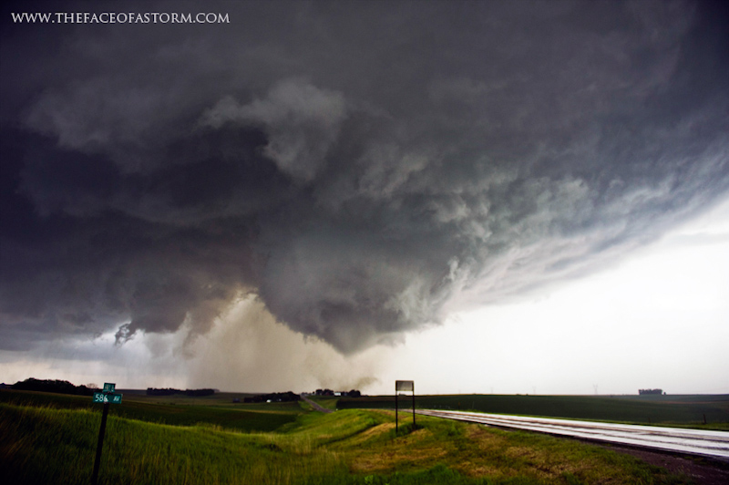
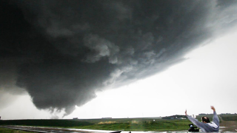
A wide angle shot captures our view of the northwest sky, showing the horseshoe shaped updraft base, RFD clear slot to the left, tornado cyclone with multiple vortex tornado, and rope satellite orbiting it.
The satellite accelerated to incredible speeds. I had never seen a tornado move that fast before. It was beginning to make a full circle around the larger parent tornado. The roar of the tight, drill bit debris cloud of the satellite was audible. At this point I was nearly overwhelmed by awe, only able to exclaim that I had never seen anything like it before.
As the satellite moved between us and the multi vortex, we could still make it out against the larger tornado. It went clear around the east side of the tornado, while continuing to rope out and dissipating somewhere on the northeast side of the parent. No doubt some remnants of the circulation continued on and were ingested by the larger, parent tornado.
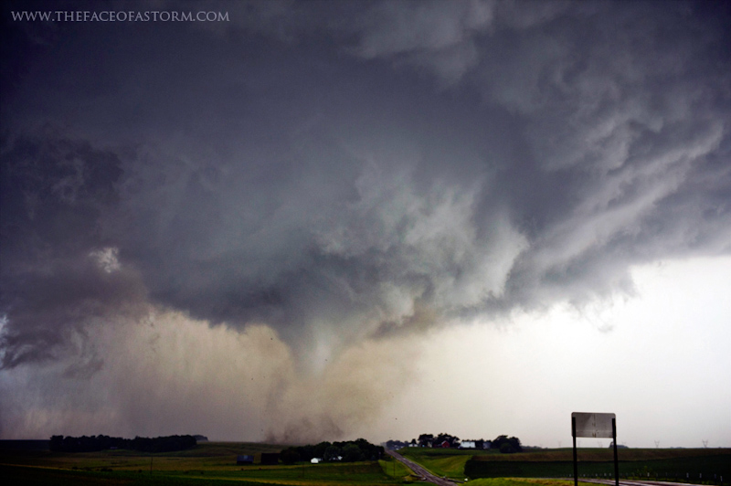
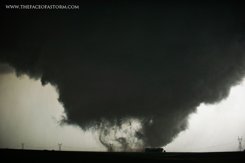
As if it had eaten the smaller tornado to add to its own mass and strength, there was a momentary pause underneath the large tornado cyclone, and then a robust funnel rapidly condensed to the ground and filled out as a large stovepipe with violent looking motion.
The tornado appeared to be gaining in size and intensity, but it was rapidly moving away from us, heading north-northeast. We opted to film it for a couple more minutes before heading north to keep up with it. The multiple vortex nature of the tornado continued. Horizontal and vertical vortices extended from the large funnel, like the tornado was made of a bag of writhing snakes that couldn’t be contained.
“Vorticity noodles” as they’ve been called, are exhibited usually on only the most violent of tornadoes, when the parameters in the environment contain huge amounts of horizontal and vertical spin or vorticity.
We packed up our cameras and piled into the van, tearing off north down a gravel road, trying to catch up to the tornado as it moved away from us. We were slowly gaining ground on it, but it soon became quite apparent that the tornado was becoming rain wrapped. It continued to grow in size, while also moving into more and more and rain. We lost sight of the tornado as a wedge, a huge shape looming to our northwest, shrouded in rain. I pushed on heading toward the rear flanking downdraft, hoping to get our view back as we approached and got past some of the rain. We wound up underneath the clear slot, a dangerously misleading benign looking place, but where tornadic winds can hit without warning. With no view and in the path of the RFD on a violent wedge tornado, we decided to abort our intercept. We pulled a U-turn and headed to our next east road to get ahead of the storm again.
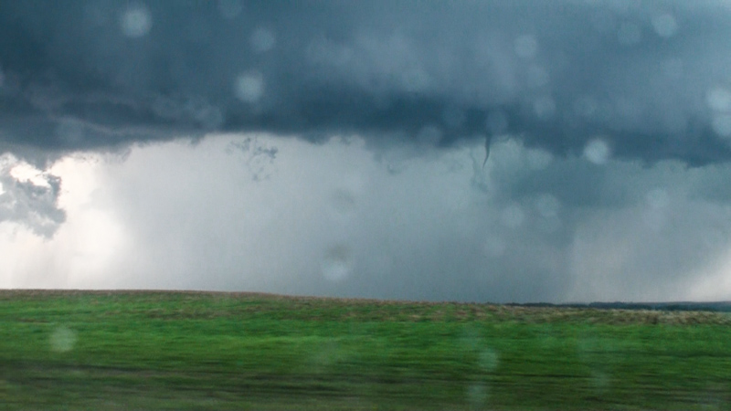
The storm appeared to be transitioning into a high precipitation mode. Rain filled the rear flank. On the southern rim, however, a tiny snake like funnel was hanging down from the base. It persisted for less than a minute before roping out and dissipating.
We caught up with Jonathan Williamson and his girlfriend Emilie as we turned north to catch back up with the storm on an unpaved road, stopping to chat for a bit while the storm cycled. While we were talking it up, “Eagle Eyes” Williamson spotted another funnel. This one, however, was dangling from a completely disconnected puff ball of cumulus well south of the storm. The rope funnel looked disproportionately large dangling from the tiny cloud. It seemed almost a freakish phenomenon to me, and a real testament to the massive amounts of vertical and horizontal vorticity that must have been present in the atmosphere. Anything with an updraft was spinning like a top and spitting out funnels.
We moved in a caravan to keep up with the storm, chatting on the ham radio. The rain had cleared out under the base, and it actually appeared like it was taking on more of a low precipitation state. Our north bound gravel road came to the top of a tall hill and we decided to stop to shoot structure, when another funnel started to dangle from the horseshoe shaped base of the supercell. We scrambled to get cameras ready to shoot another tornado. Other chasers reported a circulation at ground level with the funnel, but we couldn’t confirm it at our position, so we didn’t count it as a tornado. The funnel soon retreated after we stopped as well.
The view from our position was absolutely spectacular. A twisting barber pole of convection stretched far overhead marking the supercell’s updraft tower, with a classic RFD cut underneath, and a rapidly rotating point that was spitting out brief funnel clouds. It was textbook storm structure.
The leading edge of the updraft tower was producing small, mid-level funnels.
Meanwhile, the lowering underneath the base persisted with rapid rotation. Dust might have kicked up underneath, but an obvious tornadic debris cloud was not apparent from our position. I time lapsed the storm twisting away. We followed it on 20 toward Sioux City, but it was becoming quite obvious that the storm was dying, shriveling up into nothing. It had apparently hit some dramatic change in the atmosphere, stable air perhaps, which was causing a quick demise. It’s a good thing. The storm had now produced four violent tornadoes, and it was on a course directly for Sioux City. Had the storm gone on to produce another significant tornado, it could have been a huge catastrophe.
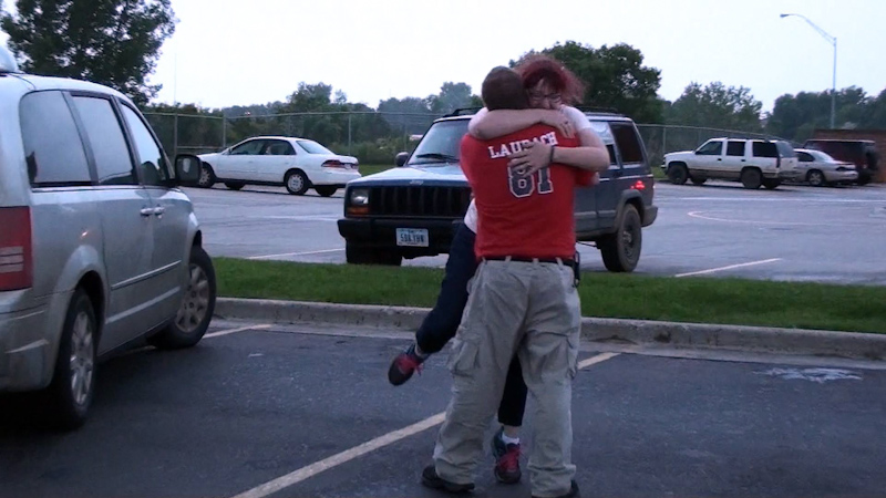
We found ourselves in Sioux City, underneath benign convection and rain showers, many miles away from the next chaseable target, so we decided to stop and get some dinner. We wound up at Applebee’s, the five of us gathered at a table, absolutely blown away from the chase. Brindley and I had such an intense experience that, as we were coming down, we actually had some minor flu like symptoms. We drank some ice water to cool down, unable to focus on anything or eat. Afterwards we met up with Tony Laubach, Ed Grubb, and crew. It was an emotional reunion after an intense and amazing chase day.
The day wasn’t over yet though. Lines of low topped storms were moving over Sioux City. The bases churned and swirled ominously. We stopped in the middle of the city to watch the bases. We didn’t see anything tornadic, just a bunch of scary looking clouds under the likely elevated storms, but they sure did look dramatic. We got rooms at a downtown conference center hotel. A severe MCS raged outside with howling winds, torrential rain, and an amazing lightning display. Brindley, Phil, and I watched it from outside underneath the enclosed loading area. We felt like hurricane chasers watching a land falling tropical cyclone from a concrete parking garage.
The damage path survey, which indicated that the Pilger EF4 made it almost to the track of the Wakefield EF4. The proximity suggests that the satellite tornado we witnessed was not a new tornado, but the rope out phase of the Pilger tornado, which then became a satellite of the Wakefield tornado.
I had never seen a tornado move as fast as that satellite had. I had to know exactly how fast. Using our GPS position and the positions of other chasers and their videos, I was able to triangulate the fast moving satellite's positions at times where it appeared to be moving the fastest. I estimated it to be moving close to 90 mph, which is absolutely amazing. I suspect that the tornado was ejected by the storm's rear flanking downdraft and into the outer ciruclation of the Wakefield EF4, which it orbited and was absorbed into.
Conclusion
This was my best chase since 2010. We counted just three tornadoes, but the display of epic force, dramatic structure, and combinations of tornadoes was like nothing I had ever seen before. Many other chasers would count more tornadoes, but the storm produced just four significant tornadoes, each rated EF4. It was the first time I had ever seen concurrent violent tornadoes, and the first time I had seen three violent tornadoes in one day, let alone on the same storm. The event deserves to be studied for its many remarkable properties, including its ability to produce concurrent violent tornadoes, positive CG barrage, plethora of funnels, and complex tornado interactions.
Unfortunately, the Pilger EF4 was also a killer. A young girl lost her life when her family's trailer was struck. The tragedy underlines the importance of having a plan for what to do during a tornado and having safe shelter to go to. Quite a bit of controversy and criticism was created when one chaser chose to document the death that occurred, while also appearing to make comments that indicated they were out to profit from such tragedies. Serious questions about the motives of storm chasers need to be asked, or at least reminders made as to why we're out there. While storm chasers seek events such as the June 16 storm, respect and consideration for those in the path must be given, and as caring human beings it's important that storm chasers give back where they can, acting as either storm spotters, first responders, or rendering aid later. Storm Assist, a 100% volunteer organization run by storm chasers, was able to organize a short order fund raiser for the town, raising thousands for a rebuilding fund.
Lessons Learned
- Don't waste any time getting to your target storm once it's going up.
- Keep your head on a swivel for new tornado developments, even if there are already multiple tornadoes on the ground.
- Give respect and consideration to those in the path, and help out when and where you can.