
June 5, 2016
Statistics
Initial Target
Start
End
Storm Intercepts
Tornadoes
Hail
Wind
Features
Miles
Trinidad, CO
Fort Collins, CO 11:43 AM 6/5/2016
Pueblo, CO 8:04 PM 6/5/2016
Trinidad, CO
0
0"
0 mph
Updraft Tower
335
Summary
National Geographic tornado research operations day 7. Intercepted some pretty upslope storms north of Trinidad, CO before they died or congealed into a complex.
Crew and Equipment
Chase partners: Jennifer Brindley Ubl, Anton Seimon, Tracie Seimon, John Allen, Rose Allen. Equipment: Canon 60D, Canon t2i, Canon EFS 10-22, Canon EF 50mm, Sony FDR-AX100.
Video
Details


"In perhaps my favorite wording ever, SPC refers to todays upslope play as ‘recycled moisture trajectories’. This is reflected by the 12Z surface analysis chart (below) with dew points over Colorado mostly in the mid-40s except for a single station - this is perhaps somewhat lower compared to the models - nonetheless, moisture in the TX panhandle and eastern NM is around the low to mid-50s so a scenario where moisture gets into the mid-50s for northern NM and southern CO is certainly plausible . A lot of todays potential seems to be related to whether a model initiates a lee trough/low effect in the desired area - for instance the 6Z NAM has hinted at both the Pueblo/Raton convergence zone and perhaps even the DCVZ forming later on today, assisting with the low-level helicity in the area. The likelihood of this has increased with a weak shortwave over Wyoming this morning that will likely provide at least a modest forcing for lee development and put effective shear into the 30-35 knot range (so happily into upslope favorable shear territory).
Jenn’s assessment of of the SBCAPE/CIN part of the play is fairly close to expectations, with capping more hostile with the surface high pressure further eastwards in addition to an orphan EML plume that actually lies on the eastern CO border region. Both NAM and HRRR happily develop convection along the high terrain, with NAM being a little more bullish in moisture return contrasting the more conservative HRRR. Nonetheless, the moisture values in CO this morning seem to be on track with the model forecasts which means the main questions come down to a) the degree of moisture return and b) the depth of moisture and its quality. Cell mode does seem to be in question in the model forecasts, with multicell/supercell modes indicated - however, as we are over high terrain, the degree to which this is reflective of actual storm mode is questionable. It is also not implausible that there is a little Colorado/high terrain magic, given the dews are certainly in range of the marginal environment needed for tornadoes in this region. Further northwards, cells may also form off the front range near Fort Collins or the Cheyenne Ridge and track SE, possibly as well over the Palmer divide, however anaemic moisture over this area would point to greater storm modal issues, unless the NAMS bullish moisture return is more realistic in which case the more discrete convection may be a more favorable target.
Given this information, I tend to also favor a southern target perhaps near Trinidad with Pueblo being a reasonable starting point for initiation over the high terrain westward. HRRR has been getting highly excited over the Black Mesa as well, which is worth watching. Given we have the longest drive, will start to head south in the nearish future to position but can divert elsewhere as needed. "


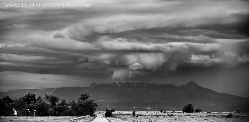


"Pork green chilli very favourably kicked off the Sunday morning as we departed south for a target area of nearabouts Trinidad CO. Marginal dew points in southern CO and northern NM provided a “recycled” upslope flow potential. Modest CAPE around 1500j/kg with effective shear of 25-30kts appeared likely to foster storm development south of the Colorado Springs area toward the Raton Mesa. Clear, crisp blue skies prevailed as we headed south, offering stunning views of the Rockies to the west. As the day evolved, the dominant high based cells were on the western side of the lee low, leading to left moving characteristics. We were delayed an hour by a flat tire fixed chivalrously by the knights of AAA, allowing us to be on our way rather speedily toward the cells initiating off the Raton Mesa. There were some nice photographic opportunities from the northwest of the storm as we approached further south from Pueblo. Storms struggled to move off the mountains, and frequently formed only to evaporate over the lower terrain. Storms further south in NM were more numerous and congealed, with right movers moving directly south into an increasingly messy convective mode. The chase was called early and we retired to our hotel deck to watch lightning that evening as the sun set over the Spanish Mountains. "

Conclusion
Pretty day on the upslope, but not much of a chase catch on this one. It's tough not to bust when you've only got scraps to chase.
Lessons Learned
Follow On The Web!


Storm Chasers Giving Back!

Webpage, graphics, photos, and videos © Skip Talbot or respective owner 2018.
skip.talbot@gmail.com Skip's Webzone