
June 6, 2016
Statistics
Summary
National Geographic tornado research operations day 8. Tracked upslope storms in marginal moisture/flow environment toward Cheyenne Wells with a brief tornado warning, but noting nothing more than pretty updrafts and precip cores.
Crew and Equipment
Chase partners: Jennifer Brindley Ubl, Anton Seimon, Tracie Seimon, John Allen, Rose Allen. Equipment: Canon 60D, Canon t2i, Canon EFS 10-22, Canon EF 50mm, Sony FDR-AX100.
Video
Details


"Moisture trajectories have failed to follow the optimistic path the models painted yesterday, meaning that values today will be confined to the upper 40s and lower 50s for most of Colorado, perhaps with higher values in the SE part of the state. This will likely retard CAPE into the 1000-2000 J/kg range, with weaker ML parcel. Sources of initiation appear to be somewhat abundant, with both the high terrain associated with upslope flow and initiation on the southward moving cold frontal boundary. This will lead to widespread thunderstorms along the front range, off the Raton mesa, and Black Mesa, and over the Palmer divide where both the front stretching along I70 and the upslope regime will produce a favorable environment for thunderstorm development. If wide coverage of storms develop, there is a likelihood of upscale growth, particularly in the southern CO/east NM/ OK Panhandle.
Moisture is depicted by HRRR and NAM4km to be confined more southward by the surging front, with convection driving this southward with a dry punch as well. This would point to more high based storms, with outflow gusts likely to be the dominant severe factor, and perhaps some hail. Particularly in early storm development along the east west boundary on the high terrain, there is landspout potential based on steep low-level lapse rates, but this is may be tempered by the relatively high storm bases. Right moving storm motion will be to the SE/S, with NW flow at elevation and southeasterly upslope flow. Both CAMS develop extensive convection in the prescribed areas, though these models tend to overdo the areal initiation.
In light of these factors, my initial target would be Limon, CO with a view to storms developing over the higher terrain and interacting with the boundary. Perhaps the multi-storm moisture amplification may assist storms locally sustaining lower bases."

"We awoke to clear blue skies and crisp views of the Spanish Mountains from our hotel, and following a detour to Sugarite Canyon, we headed north to our rendezvous point in Limon CO.
Upslope flow over eastern and southeastern CO appeared likely to be the primary driver of convective development for the day, along with a near stationary front. The expectation was for storms to develop in response to southeasterly upslope flow over the Palmer Divide. A near stationary cold front was expected to stretch across the i70 corridor, though it later materialised further south, providing a source of localised vorticity combined with modest CAPE and effective wind shear of 30-40kts, suggesting there should be a window for supercell thunderstorms or higher based landspouts, particularly if they could derive additional vorticity from the boundary. As with all days in CO, our expectation was for an early start somewhere between 1-3pm. However it also appeared likely that capping to the east may lead to relatively elevated storms, suggesting an early intercept would be necessary before dew points became heavily mixed.
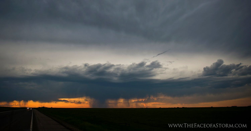
Cells fired along the northwest/southeast boundary stretching from near Denver out into eastern Kansas. Anaemic moisture towards the Palmer Divide meant that cells forming further east and south of Limon were in a more favourable development region, with dew points approaching the low to mid 50s. We headed southeast toward Kit Carson where a cell looked favourable, though shortly afterward, the right mover stopped looking so swell, and we were left with the sinister of the two. We pursued the severe warned storm towards Kit Carson and onwards then to Cheyenne Wells. The storm was briefly tornado warned, with the origins of this warning being local law enforcement reporting of a funnel cloud. The storm remained severe warned though a left mover, and while it produced some amazing views of its updraft and precipitation foot, it collapsed as it approached the Kansas border at lower elevation. We decided to reposition west toward other maturing storms and potentially better dew points north of the front.
We drove northwestwards toward Fort Morgan in hopes of intercepting one of the storms heading off the front range. However, given that the storms were weakening or congealing into larger clusters, the team decided to call the chase and enjoy a well earned rest before retiring for the night. Importantly, we found our team mascot at our hotel room this night."


Conclusion
It was fun to see a tornado warning on a marginal day and a pretty slow run of chase days, but ultimately it didn't feel justified as nothing we saw was close to being tornadic.
Lessons Learned

Webpage, graphics, photos, and videos © Skip Talbot or respective owner 2018.
skip.talbot@gmail.com Skip's Webzone