April 13, 2018
Statistics
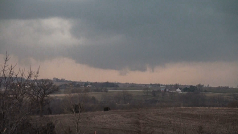
Springfield, IL 10:37 AM 4/13/2018
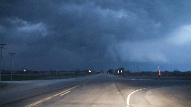
Springfield, IL 1:30 AM 4/14/2018
Summary
Triple point/warm front play in far nw MO/sw IA. Targeted cells initiating south of surface low center tracking ne toward warm front in sw IA. Cap killed initial activity, but intercepted line forced off of cold front that evening near Clarinda, IA noting rain free base and shelf cloud under pretty sunset colors.
Crew and Equipment
Solo chase. Equipment: Sony AX100, Canon 60D with EF-S 10-22.
Video
Map
Details

An impressive trough and deepening surface low were forecast to eject over the NE/KS/MO/IA corner on Friday evening, bringing dews into the 60s on strong southerly surface flow and moderate instability beneath steep midlevel lapse rates. The shape and depth of the forecast low got my attention and initial models showed backed winds across the warm sector and impressive effective storm relative helicity due to a kicking low level jet. The setup looked a little less favorable the night before and morning of the event, however, with the front sagging under super cold air that was damming it up to the north and making it too sharp. Surface winds weren’t forecast to be as nicely backed, meaning the best directional shear for tornadoes would be limited to the warm front. And the warm front was too sharp to allow for a window of opportunity in which storms could have some time to organize rotating updrafts. They’d simply cross into cold air and go elevated. Still, I thought there was a glimmer of hope if a storm initiated on the thermal axis south of the low during the mid to late afternoon, spent some time developing a robust updraft across the unstable warm sector in northwest Missouri, and then organized into a supercell as the winds finally backed and directional shear picked up by evening. Hopefully the storm would produce a tornado while it was still in the warm sector, or at least squeak a brief one out on the warm front as it crossed. Timing and placement were everything, and this setup had a high probability of busting. I decided to go for it anyway, spurred on by votes of confidence from the SPC day 1 outlook and favorable morning runs of the HRRR. To the south across Arkansas, more favorable shear and instability combinations existed, but I consider that area “no man’s land” due to the terrain and tree cover, which make chasing down there nearly impossible and dangerous even.
I was rolling by a quarter to eleven down 72 to 36 across western Illinois and northern Missouri. Perhaps this was a bit late, but I wasn’t too interested in the initial activity coming off the dry line in Kansas, near the warm front in Iowa, or right on the triple point by Omaha as I thought storms would need more time in the warm sector to develop first. Morning elevated storms were going up all over western Illinois with some impressive cloud to ground lightning that was striking in nearby fields. It would actually be the best lightning I’d see all day.
I stopped for lunch in Cameron, MO. The triple point and warm front were already awash in mediocre storms, and the Kansas dry line was starting to light up as well. I decided to catch one of the dry line storms, but after it crossed the Missouri River and somewhere along the MO/IA border.
I attempted to head north toward Maryville to intercept Tail End Charlie, but the cap must still been well in place, or as the emperor would say, “I’m afraid the deflector shield will be quite operational when your friends arrive”. Within a few scans, my target storm was completely gone, and the next one up in the line, which had been a formerly severe warned supercell, was rapidly weakening as well. The activity further north in Iowa looked quite mediocre and would quickly cross the warm front.
For a while I was worried that I was going to endure a solid cap bust and go home without having intercepted any storms at all at my target area. But then the cold front forced a north south line of storms on the Missouri River by early evening. The updrafts were robust, but didn’t look like great chase targets initially. They weren’t discrete and looked to be trending more toward a forced linear MCS rather than supercells. I hoped the shear was improving across the warm sector or that storms would briefly organized as they crossed the warm front, so I decided to push on and crossed into Iowa.
I drove north as the north south line of storms approached from the west. The evening light was starting to become quite striking for photogenic storms. I passed textured, golden updraft bases and dark translucent rain shafts. The bases looked high, however, and the bases soon filled in with rain as the updrafts congealed. I lost data once I crossed into Iowa but made for the last known location of the warm front. After punching the line and then getting ahead of it to the east, I stopped south of where the warm front had been, and then watched an updraft approach from the southwest. It displayed a bit of a lowering for a bit and I was hopeful I would finally see something attempting to organize. Getting out of the car, however, the air was super chilly. The warm front was sagging south, under the weight of the cold air and high pressure damming it from the north.

Sunset Storm
It was at that point that I realized my supercell (or tornado) chase was over. Even Tail End Charlie on the line would not have time to organize but would just quickly cross the warm front and go elevated. I started heading back south to route for home, and let the line overtake me. I got a smattering of one inch hail in the core so at least I saw some severe weather. Lighting on the back end of the line was exquisite: golden updrafts to the west and a neon blue horizon to the east under the precipitation cores. I cut east on highway 2 and noted a dramatic ground scraping shelf cloud to the north with a big whale’s mouth extending south of it. It looked like super interesting structure, even if it wasn’t tornadic at all. The sunset colors were starting to paint it pink as well. Had this storm actually been in a position to produce, it could have been extremely photogenic. A golden or pink cone or rope is the dream catch, but it will have to wait for another day.
I grabbed a selfie in Mount Ayr after spotting a sign above an ice cream shack that read “TORNADOES”. The storm was well off to the north now and I let it go at dusk. The gust front extended well south into the clear air, however, and hit while I was stopped, turning the parking lot into a big dust storm. Then it was just a grueling 5 hour drive home, the last hour in the rain before I finally arrived back in Springfield by 1:30 am
Conclusion
Apart from the bit of severe hail and pretty colored storms at sunset, this was a solid bust as I expected more of a supercell and tornado play.
Lessons Learned
- Watch out for that gust front if you stop in a dusty parking lot while grabbing a bite.